7 Best Free Terrain Generator Software For Windows
Here is a list of Best Free Terrain Generator Software For Windows. These freeware are used to generate terrains and heightmaps using a variety of drawing tools and customization features. You first have to setup parameters like map size, color, displacement, noise, warping, etc. You can then define various environmental components and setup related parameters to create terrain. These components include water (water object, water level, center, max radius,), atmosphere (haze density, bluesky density, height control, sun location, sun minimum ambience, etc.), lighting (display type, intensity, altitude, latitude, slope, facing, blending), etc.
In some of these, you can also import heightmaps, surfaces, textures, etc. in BMP, JPEG, PNG, etc. formats. You can then modify the imported data file with provided tools. These provide various drawing tools which can be used to shape up terrain, such as raise surface, lower surface, fill, cliffs, bulldozer, leveler, smooth, noise, etc. Some of these terrain creator software also provide options to select lightmap style, texture filter, display options, etc. Most of these are 3D terrain generator as these provide 3D view to design and navigate through the created terrain.
The export formats in these terrain generators vary from one software to other. Some of the common formats include BMP, JPEG, DXF, PNG, PCX, etc.
My Favorite Terrain Generator:
Terragen is one of my favorite 3D terrain generator software for Windows. It is a feature rich software which creates a realistic image of a terrain with specified parameters. L3DT is also a good heightmap generator as it lets you create various types of terrain maps including Perlin heightmap, fractal heightmap, etc.
You may also like some best free GIS, Map Maker For Games, and Map Making software for Windows.
Terragen
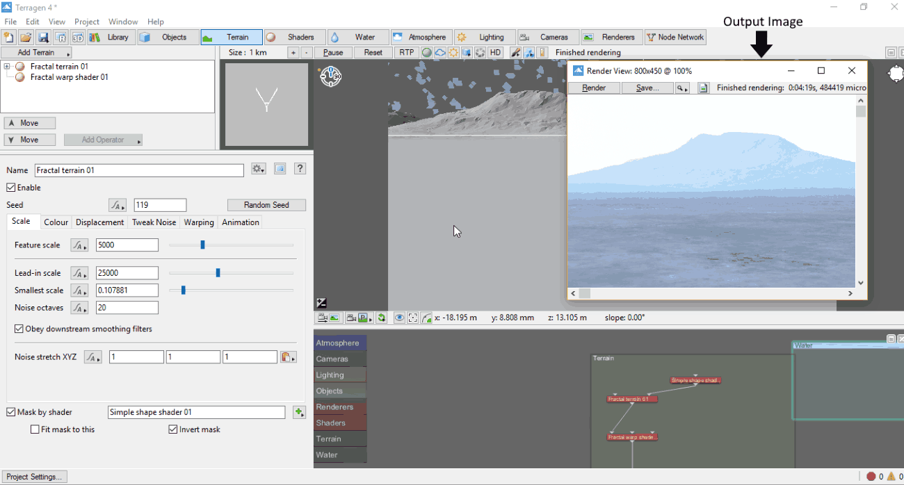
Terragen is a free terrain generator software for Windows. It is a feature-rich software which lets you build and render terrain images. In this freeware, you get control over various components and parameters to create a terrain. Let’s see what are the sets of features and tools you get in this 3D terrain generator.
The main interface of this terrain creator is categorized in different tabs to let you customize different objects and related parameters to build a natural environment. A real-time preview of generated terrain is also provided on the interface itself.
The main modules of this free terrain creator software:
- Terrain: Here, you can name the terrain you are creating and customize its parameters. These parameters include Scale (feature scale, lead-in scale, smallest scale, noise octaves, etc.), Color (apply high color/ low color, color contrast, color offset, color roughness, etc.), Displacement (amplitude, offset, roughness, spike limit, coastline, etc.), Tweak Noise (noise flavor, ridge smoothing, gully smoothing, noise variation, etc.), Warping (distort, lead-in warp, etc.), and Animation (4D noise speed, reference frame number).
- Shaders: This tab lets you add various surface layers and child layers and customize parameters including Color, Luminosity, Displacement, and Smoothing.
- Water: Here, you can add water object (Lake) and specify parameters like transform (water level, centre, max radius), planet (create and assign planet), surface shaders (assign a created shader, displacement tolerance), and Import (import chan file).
- Atmosphere: You can adjust atmosphere properties, such as haze density, bluesky density, height control (haze exposure light, bluesky exposure light, ceiling adjust, etc.), lighting (haze glow, environment light, etc.), shadow functions, tweaks (ambient, fake dark power, bluesky density colour, etc.), and quality.
- Lighting: You can select a lighting from Global Illumination and Ambient Occlusion and vary related parameters including strength on surface, color on surface, strength in atmosphere, and color in atmosphere.
Other features that you get include Library module (add icons), Object (objects used in terrain), Camera (render camera settings), Node Network (view all nodes and elements used), etc. You can render the created terrain and view its realistic image by pressing F3 key or using dedicated option anytime. Rendering time is also displayed and you can save the rendered image as TIFF, BMP, SGI, and RGB files.
Terragen is a highly recommended terrain generator software for professionals as it produces high quality terrain images. It provides various additional tools like insert clip files (TGC), error and warnings, 3D preview, etc.
L3DT
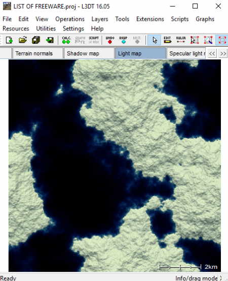
L3DT is an acronym for Large 3D Terrain. It is a free terrain creator software for Windows. This free version contains few feature limitations as compared to its full version, like batch feature is unavailable, map size is limited to 2048 × 2048 pixels, etc. You can see full comparison list here.
You can design a few types of maps including designable map, Perlin heightmap, fractal heightmap, and blank heightmap. These heightmaps differ on the basis of algorithms and configurations. You can also import heightfield, design map, texture map, color map, etc. to the current project and perform different calculations and operations. It also lets you add different map layers to your project with layer type (heightfield, water map, attribute map, etc.), layer size, etc.
As you start a new project, it lets you choose the desired project type and specify the heightmap size (width, height, horizontal scale, split map into tiles, etc.). In addition, you need to setup design parameters like average altitude, altitude range, lakes, erosion, default climate, etc. Based on the chosen project, you need to set up parameters for the algorithm. For example, for Perlin heightmap, you need to specify feature scale, octaves, persistence, altitude range, etc. Next, you have to select components for Calculation Queue including Heightfield, Water map, Attributes map, Light map, Texture map, and Terrain model. Also, you get to configure options for water flooding (water level, water type, etc.), water table modeling (maximum depth, rise parameter, fall parameter, etc. ), light mapping (sun position, colors and intensity), and light/water effects. You can save any of these configurations as presets and use them later. From Resources menu, you can manage climate, materials, masks, and overlays properties.
The display options you get include display effects like draw mosaic tiles/scale bar/map titles, show water table salinity, show gradient coloring, etc., set view area, image drape, etc.
From Operations menu, you can view and manage Calculation Wizard and other operations, such as Design map, Heightfield, Water map, Attributes map, Terrain normals, Light map, Alpha map, etc. Also, you can edit heightfield in 3D using tools like raise brush, lower brush, raise to, lower to, cliffs, bulldozer, leveler, smooth, Perlin noise, etc.
Some other useful tools present in this heightmap generator software are Design map brush (altitude, peak rough, terraces, erosion, climate, etc.), Water flood tool, Ruler (to measure distance between two coordinates), etc.
You can save the project as an L3DT project file only. But, it lets you export chosen map layer in multiple file format, such Terragen, Wavefront, DirectX, 3D Studio, GLScene, RAW, BMP, PNG, PCX, PGM, etc. You can also edit format specific options. In addition, you can set up format preferences using dedicated option from File menu.
L3DT is a featured heightmap generator software for Windows. It provides some additional utilities too, like RAM chart, Throttle CPU, Event Log, Georeferencing, etc.
EarthSculptor
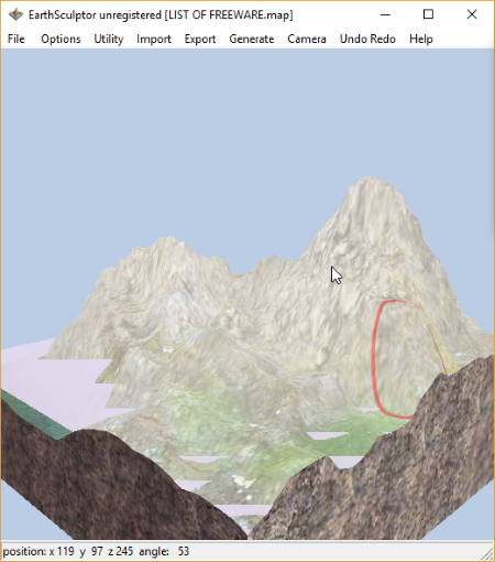
EarthSculptor is a feature rich terrain creator software for Windows. The demo version of this software can be used for free and without time limitation. But, it has various feature limitations such as terrain size is limited to 257×257, etc.
You can create a new map by specifying map size and texture size (colormap, texture splitting, detail texture, lightmap, etc.). Also, you can import a heightmap in TGA, BMP, or PNG format. In addition, it also provides some sample terrain maps which you can load and alter. It provides six tools to build and shape the terrain map which can be accessed from Toolbar panel. These tools are:
- Terrain: You can setup general configuration using this tool, like level of detail, maximum height, color texture map, detail lighting, color mode, fog, fog material, etc. You can also set sky box using files in BMP, PNG, TGA, and DDS format.
- Terraform: Using it, you can alter the terrain by raise, lower, grab, level, smooth, erode, push, and ramp tools. While using any of these tools, you can vary their parameters like radius, softness, and strength.
- Paint: To modify color and texture of the map.
- Detail: It lets you set detail textures for the map by setting up parameters like slope, radius, strength, softness, noise, scale, etc.
- Lighting: Here, you can generate entire lightmap and change sun’s direction and shadow. Other parameters to modify include Ambient, Blur, Pitch, etc.
- Water: You can enable water to display it on the map while adjusting parameters like height, scale, opacity, speed, refraction, distortion, and water material.
It provides two methods to render the custom terrain map which are Perlin Noise and Detail Height. The final terrain map can be exported as heightmap image or terrain texture (PNG), you can simply save it as object (.obj).
EarthSculptor is a great software to create terrain in real time. It produces high quality terrain maps.
Nem's Mega 3D Terrain Generator
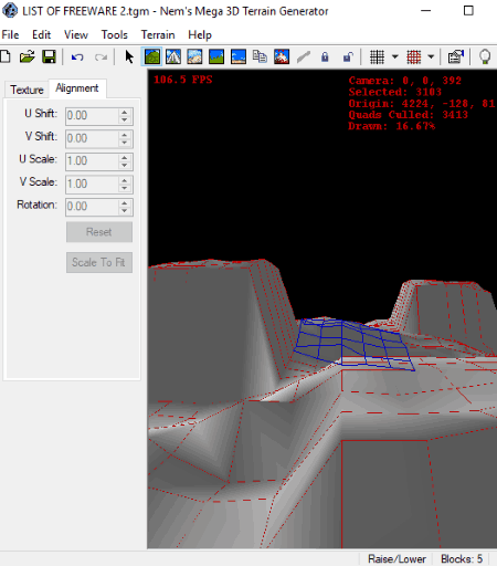
Nem’s Mega 3D Terrain Generator is another free terrain creator software for Windows. It provides quite a variety of tools to let you create a custom terrain. You can create multiple fractal and heightmap terrain using it. To start with, you can specify terrain size (X triangles, Y triangles) and shape up your terrain using tools including Pointer, Mountain/Valley, Raise/Lower, Smooth, Noise, Flatten, Touch Up, etc. Now, let’s see the control you get to generate terrain in this software:
- From View menu, you can choose the desired render mode from Textured, Solid, Wireframe, and Points. For rendering purpose, you can choose to render skybox, water, and/or compass.
- From Tools > Options, you can setup various input and output terrain generation parameters. These options include General Options (water level, sun location, sun minimum ambience, etc.), Tools (small radius, medium radius, large radius, speed, smart threshold, etc. for each tool), Camera Options (camera speed, speed boost, near clip plain, far clip plain, field of view), Texture (add texture graphics in TGA, JPEG, or BMP format), Package (add a package in WAD format or a folder of textures), and Exportation (export style, export surface, file format specific options).
- A Texture Browser is provided t0 view all added texture images.
- Using Texture > Generate option, you can customize various configuration and algorithms to use, such as geometric options (circle algorithm, flatten zero areas), noise (maximum noise), faults (circle fault algorithm, line fault algorithm), smoothing options (linear, radial, passes, oversampling, threshold), erosion options (passes, steep angle, transfer percentage), reset terrain, shift terrain, scale terrain, bound terrain, etc.
- It provides different lightmap styles to choose from, including Directional, Height Based, Smooth Shaded, Flat Shaded, Color Scale, and Grey Scale.
- You can select effective radius as Small, Medium, or Large.
- You can select a texture filter from mipmapped (nearest, linear, bi-linear, tri-linear, isotropic, anisotropic) and non-mipmapped (nearest, linear).
- Outline options are also provided including wireframe, point, outline all, outline step, etc.
- Various display options can be accessed from View menu, such as FPS, Info, etc.
- Lock and Unlock are other useful tools to lock and unlock terrain as required.
After creating terrain, you can save the whole project in its own file format (TGM) or export the terrain in different file formats. These file formats are RMF, MAP, VMF, DXF, OBJ, SMF, T3D, and TXT. You can also export terrain as Heightmap in BMP and JPEG formats.
Nem’s Mega 3D Terrain Generator is a nice and easy to use terrain creator and heightmap generator software for Windows. There are few tutorials available for users to make the terrain generation process even simpler, such as Making a Cave, Generating Cliffs, and more. You can find these tutorials here > Tutorials.
Wilbur
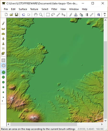
Wilbur is another one of free terrain generator software for Windows. It lets you import terrain data in multiple formats and modify it to create a custom terrain. You can import Multi-file image (DTED, SRTM), Image subsections (binary file), TerrainBase Backfill, and Word builder surface map (BMP).
It provides tools like Paint, Dig (lower surface), Raise (raise surface), Gradient Tool, Surface Tesselation, Blur, Sharpen, Smudge Tool, and Add Noise to make desired changes. You can load surfaces by importing files in various formats such as BMP, JPG, PNG, MDR, TER, TGA, BIN, STM, DEM, etc. From the Surface menu, you can use aforementioned editing tools plus Resample, Rotate, Map Info, etc. options. It lets you load textures as image files (BMP, JPG, PCX, PNG). You can customize texture of the heightmap by adjusting Lightning settings (display type, intensity, altitude, latitude, slope, facing, blending) to recompute lighting. Or, you can select a shader such as Wilbur Shader, Grayscale Phase Shader, Grayscale Slope Shader, Grayscale Bump Shader, Contour Shader, V2 Shader, etc. You can also draw map as world flood, drainage areas, river flow, clear edges, fluff edges, solid gray, etc.
It lets you add various filters including blur (gaussian blur, box filter), erosion (erosion cycle, incise flow, percipiton based), fill (fill basins, flatten block, mound, etc.), noise (fractal noise, percentage noise, etc.), morphological (dilate, erode), etc. You can also calculate height field based on specified parameters, such as type, operation, sphere center, procedural parameters, etc. It lets you emboss an image onto the surface in BMP, JPG, or PNG format.
It lets you export created heightmaps as MONSYS textures (DTE) and RangeView Terrain MIFs (BMP, RV tex). You can also process GMS Map Definition file in this software.
WorldPainter
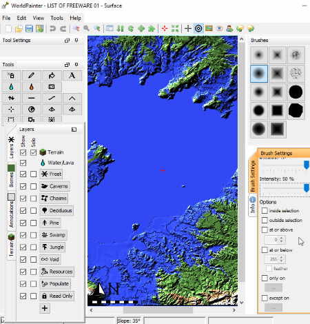
WorldPainter is the next software in this list of free terrain generators. The interface of this software contains the main editor window and various tool panels. It provides a 2D view to create terrain and to navigate through it. You can setup “view configuration” by modifying layout, background image, color, etc.
As you create a new project, you need to initialize it by specifying various parameters, such as terrain dimensions, topography (hilly, flat), water level, beaches, surface material (simple like grass, dirt, sand, dessert, etc. or advanced), Minecraft seed (ocean, land, etc.), etc. You can modify dimension properties (underground material, border, theme, etc.) using Edit menu > Dimension Properties option.
Now, you can use various tools present on its main interface. These tools include Spray Paint, Smooth, Raise Mountains, Height (raise or lower terrain), Raise Pyramid, Raise Rotated Pyramid, Global Operation (add or remove layers), Flood (flood an area with water), etc. It lets you vary properties of brush used in these tools, like size, intensity, shape, etc.
From the Layers panel, you can enable the objects you want to include in your terrain, such as frosts, caverns, chasms, jungle, resources, swamp, etc. You can also add custom objects in .schematic, .bo2, .bo3, and .nbt file formats. In addition, you can select the terrain and biomes to view on the map.
While you can import files as Minecraft Map and heightmap, the generated terrain can be exported as Minecraft map, image file (PNG, JPG, BMP, GIF, etc.), heightmap, or high resolution heightmap (BMP, JPG, PNG, GIF, etc.).
SC3K Map Editor
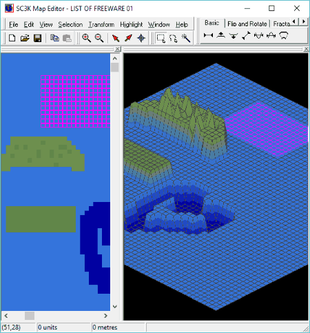
SC3K Map Editor is yet another free software to create terrain maps. To do so, it provides Topological Editor and 3 dimensional Editor view windows. You can design terrain in either of these two windows. Tools that it provides to shape the terrain include selection (rectangle, freeform, magic wand), basic (set level, raise by one, lower by one, gradient, fill, level off, scale), fractal (terrain, mountain, lake), texture (roughen, smooth), and flip and rotate. You can use the selection tool to select a particular region and then raise it or lower it or create a fractal terrain with mountain and lake. For the mountain, it lets you edit properties like base and peak, while for lake, you can specify shore and deepest point. You can highlight the selection in different colors too.
You can import a bitmap file to the software and after creating terrain map, you can export it as a bitmap file only.
It is a basic and simple heightmap generator software for Windows.


About Us

We are the team behind some of the most popular tech blogs, like: I LoveFree Software and Windows 8 Freeware.
More About UsArchives
- April 2024
- March 2024
- February 2024
- January 2024
- December 2023
- November 2023
- October 2023
- September 2023
- August 2023
- July 2023
- June 2023
- May 2023
- April 2023
- March 2023
- February 2023
- January 2023
- December 2022
- November 2022
- October 2022
- September 2022
- August 2022
- July 2022
- June 2022
- May 2022
- April 2022
- March 2022
- February 2022
- January 2022
- December 2021
- November 2021
- October 2021
- September 2021
- August 2021
- July 2021
- June 2021
- May 2021
- April 2021
- March 2021
- February 2021
- January 2021
- December 2020
- November 2020
- October 2020
- September 2020
- August 2020
- July 2020
- June 2020
- May 2020
- April 2020
- March 2020
- February 2020
- January 2020
- December 2019
- November 2019
- October 2019
- September 2019
- August 2019
- July 2019
- June 2019
- May 2019
- April 2019
- March 2019
- February 2019
- January 2019
- December 2018
- November 2018
- October 2018
- September 2018
- August 2018
- July 2018
- June 2018
- May 2018
- April 2018
- March 2018
- February 2018
- January 2018
- December 2017
- November 2017
- October 2017
- September 2017
- August 2017
- July 2017
- June 2017
- May 2017
- April 2017
- March 2017
- February 2017
- January 2017
- December 2016
- November 2016
- October 2016
- September 2016
- August 2016
- July 2016
- June 2016
- May 2016
- April 2016
- March 2016
- February 2016
- January 2016
- December 2015
- November 2015
- October 2015
- September 2015
- August 2015
- July 2015
- June 2015
- May 2015
- April 2015
- March 2015
- February 2015
- January 2015
- December 2014
- November 2014
- October 2014
- September 2014
- August 2014
- July 2014
- June 2014
- May 2014
- April 2014
- March 2014
