5 Best Free Hurricane Tracking Software For Windows
Here is a list of best free hurricane tracking software for Windows. It is safe to have a hurricane tracker software on your PC, to stay alerted on the same. These freeware provide latest forecasts in order to keep you updated about the active storms in your region or other hurricane prone areas. Most of these software use FEMA, USACE, NOAA National Hurricane Center, etc. sources to fetch real-time hurricane information. You can also view reports on previous hurricanes and learn about them.
All of these free hurricane tracker software provide a map, using which you can select a region to learn about hurricane conditions. The hurricane information is displayed with central location, maximum sustained winds, distance from your location, points of origin, estimated time of arrival, and more. You can view reports of Public Advisory and Forecast Advisory too, which are updated in regular time intervals. Other active storm reports like Evacuation Timing, Wind Timing, Risk Profiles, Surge Probabilities, etc. can also be viewed. The storm summary report can be exported in PDF, TXT, etc. formats. In addition, you can save current map view as JPEG, BMP, etc. A few of these hurricane tracking software provide only forecasts and news related to active storms.
My Favorite Hurricane Tracking Software for Windows:
From this list, I liked HURREVAC and Tracking The Eye hurricane tracker software the most. Both of these provide real-time hurricane related information. They also let you study and learn about active and past storms in detail. Keep reading to know more about them.
You can also checkout lists of best free Weather Software and Eye Tracking Software for Windows.
HURREVAC
HURREVAC is a free hurricane tracking software for Windows. It is administrated by FEMA, USACE, and NOAA National Hurricane Center. This software is especially designed to provide support for decision making in an emergency situation.
It provides reports and advisory for various hurricane storms in different regions in real-time. These regions include hurricane prone areas which are Atlantic, East Pacific, West Pacific & N. Indian, Central Pacific, and South Pacific & S. Indian. These areas with active hurricane storms are displayed in Current tab in the left pane of the interface. As of September, 2017, the active hurricanes are Irma, Jose, and Katia. You can also fetch reports on old hurricanes in current year, and storms in previous years up to 1996 in Archives tab. Using New System Message button, you can access key message on new threats from currently active storm.
In Map tab on its interface, you can view latest information on the currently active storm. There you can view Central Location, Maximum Sustained Winds, and Movement of the storm. Different colors and symbols’ schemes depict different states of the regions. The Watches and Warnings for hurricane and tropical storm in different regions are also displayed. Also, Sustained Winds Speeds for tropical storms, strong tropical storms, and hurricane in various regions can be viewed. You can zoom in to a region to look specifically for it in the map. The estimated time of arrival in coming days for the active storm is also displayed on the map.
Public Advisory and Forecast Advisory reports updates from different hurricane centers are shown in the Advisory Tab. These reports are updated on regular time intervals as the new updates are received. Other reports including Evacuation Timing, Wind Timing, Rain/River, Inland Wind Effects, Surge Probabilities, Storms Statistics and Track, Risk Profiles, NYC Metro Facilities, etc., can also be fetched. These reports can be copied from the clipboard or exported as TXT or PDF file. You can also generate Storm Summary of Active Storm of current day in PDF form, including advisory text, wind timing for selected country, and evacuation timing for selected location.
From the Setup menu, you can customize some preferences for automatically checking for new storm updates, schedule time interval (5 min, 10 min, 15 min, etc.) for these updates, default area selections to draw active storms on the map, local area selections (Arizona, California, Florida, Georgia, New Jersey, New York, etc.) to generate storm reports, etc. In the same settings, you can add Points of Interest manually. These Points of Interest are displayed on the map, and are used to create many location specific reports. You can add them by right-clicking on a region in the map and choosing Create Points of Interest option. And then, entering name, latitude, longitude, and type. Time Zone can be set accordingly, and Timeline and Map settings can be modified as per your choice.
It is a great hurricane tracker tool, which provides you updated hurricane reports to stay alert. It also lets you add other Storm Features like Wind Prob Locations, Alternate Forecast Track, etc. Also, you can customize Map Annotations and Evacuation Options. It is advised to keep updating software using Update Now feature, for latest news.
Tracking The Eye
Tracking The Eye is another free hurricane tracking software for Windows. It is designed in order to track updates and generate alerts on current hurricanes.
- In the Main Tracking Map, as you hover over a city with your mouse, NOAA Live Data fetches required information related to current storms. This information includes distance from that city to the current storm location. Also, it displays the speed of storm to reach that particular city in days. This information is fetched in real-time.
- You can access latest Public Advisories and Forecast Advisories reports in Atlantic and Eastern Pacific regions. A monthly report on tropical weather can be viewed in Summary tab. In addition, you can see the latest hurricane news, posts related to hurricane on Facebook, tweets about hurricane on Twitter, etc.
- Tropical Weather Discussion and Storm Discussion from National Hurricane Center can bee seen in respective tabs.
- From Map Data, you can fetch storm information (longitude, latitude, wind speed, speed of travel, pressure), city information (state, country, longitude, latitude), storm gauges (direction of travel, wind speed, speed of travel, pressure), statistical storm graph (wind speed, pressure), and points of origin. These information can be printed.
- It provides a feature which lets you setup email and/or phone alerts to let the software inform about new storms. You can select your region from Atlantic and Eastern Pacific. But unfortunately, this service is only for registered users.
- You can open storms of previous years from its database. It contains information regarding previous hurricanes with year, storm type, wind speed, pressure, and region.
- You can export current map view as a BMP image or print it too.
- You can also explore hurricane facts.
So, in case you need updates on new storms on your PC, you can use this hurricane tracker software. It provides updated information on the same.
Hurricane Watch
Hurricane Watch is the next freeware in this list of hurricane tracking software. The map provided on its interface lets you zoom into the map, in order to track hurricane in a specific region. Toolbar present on its interface lets you easily navigate through the globe.
From the Find Storms menu, you can mention criteria for locating hurricanes. The criteria include position, distance, latitude, longitude, minimum wind speed, and year and month. The software screens storms using the specified information and displays a list of hurricanes. You can now choose a particular storm to learn about. Now, as you click on a particular state or region, a small window displays storm path, wind speed, and estimated time of arrival with date and hours.
You can save the current map view as JPEG or BMP image.
Using this hurricane tracker software, you can learn about new as well as past storms. It also lets you customize map units, appearance preferences, add your own location to the provided map, etc.
Hurricane Monitor
Hurricane Monitor is another free hurricane tracker software. It actually is a widget which requires Yahoo Widget Engine to function. It basically provides forecasts and satellite images related to tropical storms and active hurricanes. This forecast is pulled from NOAA National Hurricane Center.
On right clicking on the widget, you can customize preferences for Hurricane Monitor to fetch live updates for you. These preferences include monitored region (Atlantic only, Pacific only, Atlantic and Pacific, Pacific and Atlantic), update frequency (Every hour, Every 3 hour, Every 8 hour), how many times to repeat a looped satellite images, etc. Other settings include initial widget view (Storm Surge, Marquee Only, Storm Details, Satellite Images), initial region for satellite images and storm surge view, minimum Marquee width, widget transparency, etc.
Hurricane Monitor is a basic hurricane tracking software which provides latest news on hurricane, to make you stay alert. You can directly navigate to website of NOAA National Hurricane Center, refresh images from NOAA, open Accuweather Hurricane Site, etc.
Hurricane and Tropical Storm Report
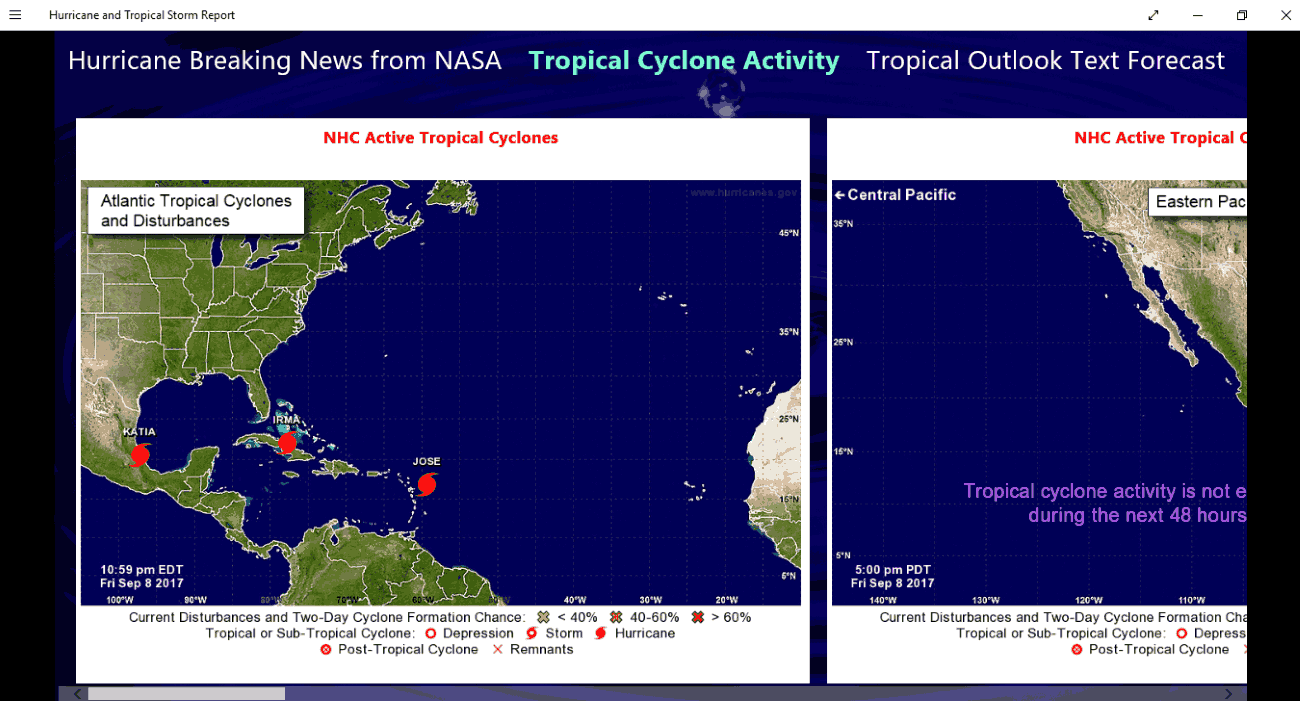
Hurricane and Tropical Storm Report is an app for Windows 10 for hurricane tracking. It displays latest pictures and news on active storms in USA and Japan. As it says, these information are fetched from NOAA’s National Hurricane Center, the Japan Meteorological Agency, and NASA. All the latest activities on the current storm are reported to you. Also, old news on hurricanes can be viewed by moving the slider present below its interface. That’s about it. It doesn’t provide any other features like other hurricane tracking software in this list. You can use this hurricane tracking app for the purpose of latest hurricane news.


About Us

We are the team behind some of the most popular tech blogs, like: I LoveFree Software and Windows 8 Freeware.
More About UsArchives
- April 2024
- March 2024
- February 2024
- January 2024
- December 2023
- November 2023
- October 2023
- September 2023
- August 2023
- July 2023
- June 2023
- May 2023
- April 2023
- March 2023
- February 2023
- January 2023
- December 2022
- November 2022
- October 2022
- September 2022
- August 2022
- July 2022
- June 2022
- May 2022
- April 2022
- March 2022
- February 2022
- January 2022
- December 2021
- November 2021
- October 2021
- September 2021
- August 2021
- July 2021
- June 2021
- May 2021
- April 2021
- March 2021
- February 2021
- January 2021
- December 2020
- November 2020
- October 2020
- September 2020
- August 2020
- July 2020
- June 2020
- May 2020
- April 2020
- March 2020
- February 2020
- January 2020
- December 2019
- November 2019
- October 2019
- September 2019
- August 2019
- July 2019
- June 2019
- May 2019
- April 2019
- March 2019
- February 2019
- January 2019
- December 2018
- November 2018
- October 2018
- September 2018
- August 2018
- July 2018
- June 2018
- May 2018
- April 2018
- March 2018
- February 2018
- January 2018
- December 2017
- November 2017
- October 2017
- September 2017
- August 2017
- July 2017
- June 2017
- May 2017
- April 2017
- March 2017
- February 2017
- January 2017
- December 2016
- November 2016
- October 2016
- September 2016
- August 2016
- July 2016
- June 2016
- May 2016
- April 2016
- March 2016
- February 2016
- January 2016
- December 2015
- November 2015
- October 2015
- September 2015
- August 2015
- July 2015
- June 2015
- May 2015
- April 2015
- March 2015
- February 2015
- January 2015
- December 2014
- November 2014
- October 2014
- September 2014
- August 2014
- July 2014
- June 2014
- May 2014
- April 2014
- March 2014
