9 Best Free Shapefile Viewer Software For Windows
Here is a list of best free shapefile viewer software for Windows. These SHP file viewers are used to view GIS shapefiles, which normally contain maps of countries, states, etc. Not just view, you can also closely analyze boundaries; thanks to various tools like zoom in/out, pan, rotate, etc. Generally, shapefiles come with a variety of data which is related to maps such as country name, coordinates, etc. While some SHP viewers show associated data in tabular format, some show data over the map and others don’t show this data at all.
These shape viewer software are also used to do study of drought-affected areas, population density, GDP of states or countries, etc. What you can study about the shape depends upon the shapefile and the data that comes with it. If shapefiles has right set of data, then you can easily know much more about the shape than just viewing it.
In few of these software, you can also edit shapefiles by using various editing tools. These editing tools include stretch, break, split, trim, etc. Overall, these software make viewing and analyzing of shapefiles easy.
These software are also capable to handle various formats other than SHP, such as AutoCAD drawing, LiteCAD drawing, SHX, etc.
My Favorite Shapefile Viewer Software For Windows:
ESS Shape Viewer is my favorite shapefile viewer because it is fairly simple to use, and also comes with all essential tools. Plus, its ability to edit shapes makes it my favorite software.
You can also check out some other software like Hurricane Tracking Software and CAD Viewer Software.
ESS Shape Viewer
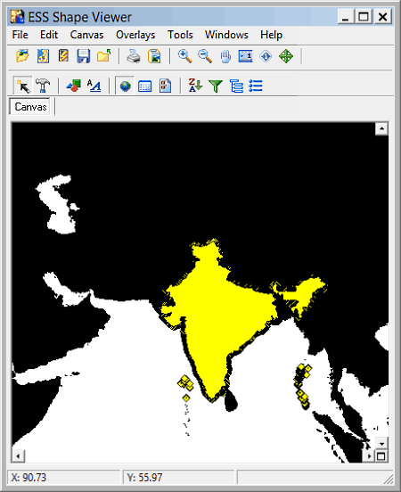
ESS Shape Viewer is a free shapefile viewer software for Windows. It is mainly used to view shapefiles (.shp) that contain shapes of geopolitical areas like countries, states, etc. You can browse and view shapefiles using its internal file explorer. Besides SHP file, it also natively supports few other file formats, namely, database, text, excel, and drawing interchanging format.
This freeware provides all necessary tools like zoom in/out, pan, distance scale, etc. to make viewing easier. Not just viewing, you can edit shapes using various available shape editing tools. Two tools named identify tools and edit shapes are quite advanced. Through identify tool, you can select a shape of a country from a map to view information like country name, area, coordinates, economy, etc. Edit shape is basically a tool to edit shapes, but the thing I like about it is that it highlights the selected shape, country, or state, and also shows number of boundary points. Highlighted region and boundary points make the analysis of shape easy.
This shape viewer also has some advanced functions such as integrating chart functions, CAD functions, shape filtering, subsets, polygon binning, shape functions, etc. All of these functions help in editing and making of shapes.
Shape Viewer
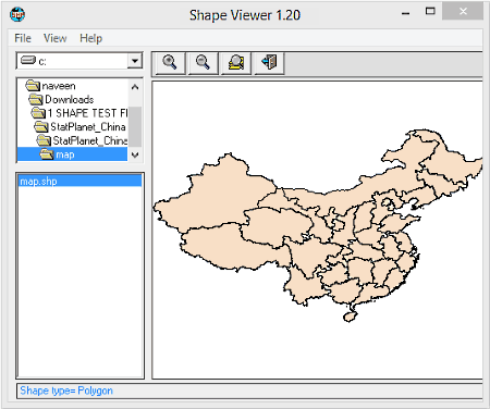
Shape Viewer is another free shapefile viewer software for Windows. It is used to view ESRI shape files (.shp). Using it, you can view all the geometrical information contained in a shapefile. It also helps you to study and analyze the borders of various countries, states, or any other region in details. While viewing the shapefile, you can use zoom in, zoom out, or pan tool to analyze the shape with better vision.
This freeware provides its own file explorer through which you can browse and view any shapefile. Besides .shp file, it does not support any other file format. However, you can create Shapefile shape index format (.shx) and an empty shapefile attribute format (.dbf) files. The important information related to shape such as shapefile type, number of records, coordinate details in X min/max, Y min/max, etc. can be viewed using this shape viewer software. Moreover, you also get the option to Export coordinates in excel file format.
TatukGIS Viewer
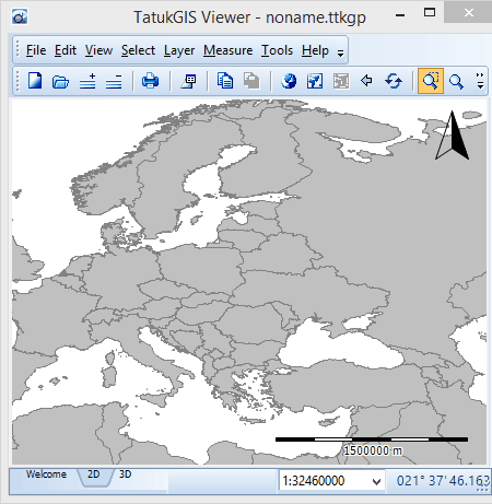
TatukGIS Viewer is a free GIS mapping and data editing software for Windows. It supports many file formats like pixel files, grid files, vector files, AutoCAD files, shapefiles, etc. It is more advanced than other shapefile viewers because it uses R-tree indexing to handle very large data layers. The main advantage of this viewer is that it can open shapefile of size up to 2GB.
On its main interface, you can view a file viewer window with many useful tools at the top. All essential tools like pan, zoom in, and zoom out are present. Apart from these tools, you also get some handy measuring tools to measure the distance of a geographical area as line, polygon, rectangle, and circle. As you know, shapefiles also contain data related to shape (geographic location) such as country name, length, area, country rank, and more; you can view these data using a dedicated data panel. Now, if you have a shapefile on a server, then you can directly view that shapefile by entering the address of that server.
Using this freeware, you can also save shapefile in PDF format or as a TatukGIS project file for later use. Overall, it provides many handy tools and features that make analysis of shapefiles and other file formats easy.
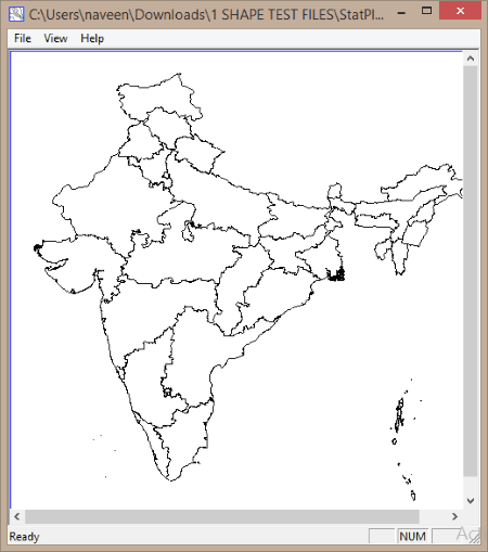
SHPViewer
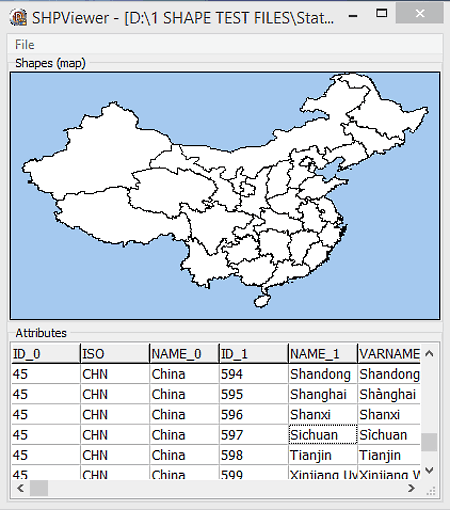
SHPViewer is a free and portable shapefile viewer software for Windows. It is a straightforward software which is used to view ESRI shapes of .shp files. Apart from .shp file format, it does not support any other file format. If input shapefile has attributes related to shape, then it shows those attributes at the attribute section.
This viewer shows outer as well as the internal boundaries of the input shapes. This property is helpful to view outer boundary of a whole country with the internal boundary of each state. This freeware does not provide any additional tool, but you can perform zoom in and zoom out by scrolling the mouse wheel.
This freeware is very lightweight and does not stress the CPU. Plus, because of being a portable software, you can easily carry it in a flash drive. It is a small software, still it can open shapefiles of very large size with almost negligible loading time.
Avangardo ShapeView
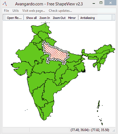
Avangardo ShapeView is another free and portable shapefile viewer software for Windows. It lets you view Shapefile, MapInfo files, and Drawing Interchange file format.
Using its file menu, you can open and analyze any supported file format. To make analysis easy, it provides a special tool named Antialiasing to have a clear vision of highlighted boundaries. Besides this, normal tools to zoom in/out and a mirror effect tool can also be accessed from the toolbar. Some smart features like the ability to pan image by holding the right click of mouse and to highlight the boundary region of selected shape are also present in it.
This shapefile viewer does not provide the option to view the attributes that come with shapefiles. But, you can export the attributes as .csv file. Simple conversion of shapefile to bitmap can also be performed at the time of saving the file.
Overall, it is another simple and lightweight software with all essential tools to make shapefile viewing and analyzing easy.
AnyChart Map Converter

AnyChart Map Converter is a free ESRI shapefile to Anymap (AMAP) file converter software for Windows. It also includes a shapefile viewer, using which you can easily view any shapefile. There is one constraint that it needs related SHX and DBF files of the same name as SHP file in the same folder, to open the shapefile. If you only have a shapefile, then this freeware will not able to open that shapefile.
In this shapefile converter, you get normal viewing tools like zoom in, zoom out, pan, fit to view, etc., which are normally available in shapefile viewers. Besides these tools, it also has a reduction tolerance tool that allows you to reduce the details of boundary region of a map. The reduction of boundary details results in the reduction of file size.
Almost all shapefiles come with a list of attributes, that contain essential attributes about the geopolitical shapes (country, cities, etc.). You can select different attributes like economy, income, name, etc. According to a selected attribute, you can view the attribute value related to different countries, states, etc., exactly over the shape of the geopolitical region.
This is overall a good shape file viewer, as you can you can view and analyze any map or country in much more details than many dedicated SHP viewers.
LiteCAD
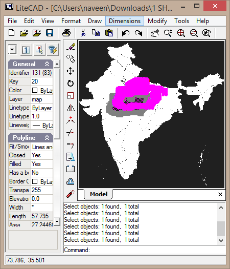
LiteCAD is a free 2D CAD viewer and editor software for Windows. It also supports shapefile format, so you can easily view and edit shapefiles as well. Few other file formats that it supports are LiteCAD drawing, AutoCAD drawing, and AutoCAD drawing eXchange format.
This freeware provides a black background and shows input shape in white color. You can easily zoom in/out, pan, or rotate shape to get a better perspective of the shape. If you select any closed internal shape, then you can view a 2D shadow view of that shape. Geopolitical data that comes with shapefiles cannot be viewed in LiteCAD, which is the only drawback of this software.
As LiteCAD is natively a CAD viewer and editor, various tools for editing are available in it. These CAD tools also work with .shp files. Using available tools, you can stretch, break, split, extend, trim or even make mirror image of input shapefile. A completely new shape from the scratch can be designed using Draw tools (line, polyline, polygon, multiline, arc, ellipse, point, etc.). The designed shape can be saved in LiteCAD drawing and AutoCAD drawing formats.
Geographic Explorer

Geographic Explorer is a very basic shapefile viewer software for Windows. It is used to view and explore geographical shapes such as maps of world, country, state, etc. Besides SHP files, you can also view files of other formats named MIF, TAB, DWG, DXF, DGN, TIFF, BMP, and JPG. This SHP viewer is also a very good file finder. You can search any supported file format in your system by using its name and location section.
The viewer section of this freeware is simple and has all essential tools to explore maps. Through available tools, you can perform zoom in, zoom out, and pan operation over the map to get a better view of the map. The side by side comparison of two or more maps is also possible as you can open multiple maps at once. If you want to know the exact latitude and longitude coordinates of any place within the map, then just place your cursor at that point and get coordinates at bottom left corner of the viewer.
Shapefile or any other file format can be saved as .oxps file, or you can also directly print the shapefiles from the viewer section.
Swirl GIS View
Swirl GIS View is a simple GIS shapefile viewer software for Windows. This software helps you to view and read geographical data of a shapefile. Through its file menu, you can open any SHP file. But besides SHP, it does not support any other format. Though you can convert SHP file into scalable vector graphics (SVG) format while saving.
From its view menu, you can open database section to study shape attributes in details. All the data of different regions of geopolitical shapes are present in the form of a list. You can select any record and view all the details of that record such as city code, name, state code etc.
It is a shapefile viewer, still it does not provide any tool to view shapefiles in detail. Even the basic pan and zoom in/out tools are not present in it. Due to lack of essential tools, you will remain stuck with the by default size of shapefile. It can be used to view shapefiles, but if you want to get a detailed view, then use some other SHP viewer.


Naveen Kushwaha
Passionate about tech and science, always look for new tech solutions that can help me and others.
About Us

We are the team behind some of the most popular tech blogs, like: I LoveFree Software and Windows 8 Freeware.
More About UsArchives
- May 2024
- April 2024
- March 2024
- February 2024
- January 2024
- December 2023
- November 2023
- October 2023
- September 2023
- August 2023
- July 2023
- June 2023
- May 2023
- April 2023
- March 2023
- February 2023
- January 2023
- December 2022
- November 2022
- October 2022
- September 2022
- August 2022
- July 2022
- June 2022
- May 2022
- April 2022
- March 2022
- February 2022
- January 2022
- December 2021
- November 2021
- October 2021
- September 2021
- August 2021
- July 2021
- June 2021
- May 2021
- April 2021
- March 2021
- February 2021
- January 2021
- December 2020
- November 2020
- October 2020
- September 2020
- August 2020
- July 2020
- June 2020
- May 2020
- April 2020
- March 2020
- February 2020
- January 2020
- December 2019
- November 2019
- October 2019
- September 2019
- August 2019
- July 2019
- June 2019
- May 2019
- April 2019
- March 2019
- February 2019
- January 2019
- December 2018
- November 2018
- October 2018
- September 2018
- August 2018
- July 2018
- June 2018
- May 2018
- April 2018
- March 2018
- February 2018
- January 2018
- December 2017
- November 2017
- October 2017
- September 2017
- August 2017
- July 2017
- June 2017
- May 2017
- April 2017
- March 2017
- February 2017
- January 2017
- December 2016
- November 2016
- October 2016
- September 2016
- August 2016
- July 2016
- June 2016
- May 2016
- April 2016
- March 2016
- February 2016
- January 2016
- December 2015
- November 2015
- October 2015
- September 2015
- August 2015
- July 2015
- June 2015
- May 2015
- April 2015
- March 2015
- February 2015
- January 2015
- December 2014
- November 2014
- October 2014
- September 2014
- August 2014
- July 2014
- June 2014
- May 2014
- April 2014
- March 2014
