10 Best Free Online Jogging Route Planner Websites
Here is a list of best free online jogging route planner websites. To ensure fitness goals while ensuring their safety, many users plan their jogging, walking, and traveling routes. A planned route also increases efficiency as users don’t need to make in-the-moment decisions related to a route. A preplanned route also ensures a fixed distance that users can jog daily to maintain their fitness goals. If you also want to plan jogging routes, then check out these online jogging route planner websites.
These websites come with interactive maps on which users can open up any city in the world and plan a jogging route on it. Most of these websites come with multiple types of interactive maps like Street View, Satellite View, Hybrid, etc. After selecting a specific map type, users can start the jogging route planning. To do that, users can manually specify the jogging route over the map which can also be edited further. After confirming a jogging route, users can obtain information about the selected route like route distance, elevation at different parts of the route, percentage of paved route, etc.
Users can save or export the final planned jogging route in GPX and KML file formats. Although, some websites only allow premium users to save and export planned routes. Many other restrictions like limited supported maps and limit on saved routes are also imposed by some websites. Go through the list to know more about these websites.
My Favorite Online Jogging Route Planner Website:
onthegomap.com is my favorite website as it offers multiple interactive maps over which users can plan their jogging routes. It also shows all the necessary information related to the planned jogging route. Plus, it lets users locally save the planned route in the form of a GPX file.
You can also check out lists of best free Online Gantt Chart Planner, Online Nmap Scanner, and Online Port Scanner websites.
Comparison Table:
| Features/Website Names | Supports multiple map types | Lets users mark and edit the jogging routes | Allows users save or export jogging routes |
|---|---|---|---|
| onthegomap.com | ✓ | ✓ | ✓ |
| plotroute.com | ✓ | ✓ | ✓ (save route on its server) |
| maps.ie | ✓ | ✓ | ✓ |
| mapmyrun.com | ✓ | ✓ | ✓ |
| komoot.com | ✓ | ✓ | ✓ |
| goodrunguide.co | ✓ | ✓ | x |
| routeyou.com | ✓ | ✓ | ✓ (save route on its server) |
| footpathapp.com | x | ✓ | x |
| routesshuffle.com | ✓ | ✓ | x |
| map-planner.com | x | ✓ | x |
onthegomap.com
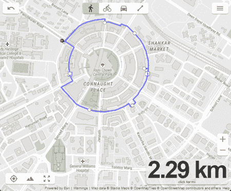
onthegomap.com is a free online jogging route planner website. Using this website, users can plan their jogging route. To plan a jogging route, it offers an interactive map on which you can open up any part of the world. After opening up a specific location, users can specify the route over a map. This map also shows the total length of the specified jogging route. An option to add per kilometer marking on the jogging route is also available. I also like its Elevation Profile option that shows the elevation of the entire jogging route.
Besides planning a jogging route, it can also be used to create cycling and driving routes. After finalizing the jogging route, users can export it in GPX file format. Now, follow the below steps.
How to plan jogging route online using onthegomap.com:
- Go to this website using the given link.
- After that, use the search option to look for a specific location on the map. It also offers an option to find your location through GPS.
- Next, specify the starting and ending locations.
- Now, now grab and release the route over a street or running path on which you want to jog.
- Finally, preview the route and export it in GPX format.
Final Thoughts:
It is one of the best free online jogging route planner websites that also shows the distance and elevation of the jogging route.
| Pros | Cons |
|---|---|
| Shows the distance and elevation of the jogging route. | |
| Lets users export the jogging route in GPX format |
plotroute.com
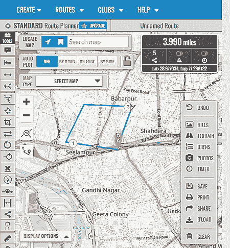
plotroute.com is another free online jogging route planner website. Using this website, users can plot and plan jogging routes, bike routes, and car routes. Plus, it offers multiple types of maps over which users can plan jogging routes like Street, Terrain, Trails, Cycle, etc. After locating a specific location and selecting a map type, users can start specifying the jogging route. To do that, users first need to specify the start and end points. After that, users can drop an anchor over the route to modify the path of the route. It also shows the total distance of the plotted jogging route.
This website offers a large number of route plotting and editing tools like Rejoin route, Reshap route, Repeat a Loop, Delete a section, and more. A handy tool to measure the section of a route is also provided by it. After finalizing the route, run animate route animation using the Play button. In the end, users can save the route within this website and print the entire route. Now, check out its main features.
Main Features:
- Interactive Map: This website offers an interactive world map on which users can find and open up any part of the world.
- Map Type: This website supports multiple map types like Cycle, Street, Terrain, Transport, etc.
- Route Planner: To plan route users need to select the On Foot option and specify the start and end location over the map. After that, users can use multiple available route editing tools to fine-tune the route path.
- Route Animation: After finalizing a route, users can run the route animation that highlights the direction and path of the route.
- Route Distance: It automatically calculates and shows the distance of the planned route in kilometers or miles units.
Limitation:
- The free version of this website restricts users from using some maps like Satellite, Hybrid, Ordnance Survey, etc.
Final Thoughts:
It is another good online jogging route planner website that can also be used to plan cycle and car routes.
| Pros | Cons |
|---|---|
| Supports multiple types of maps | |
| Offers a good number of route editing tools | |
| Shows route animation | |
| Lets users save the route on its servers |
maps.ie

maps.ie is another free online jogging route planner website. This website offers a simple map my route that comes with an interactive world map on which users can open up any part of the world and plan a jogging route on it. To do that, users need to specify the path of the jogging route by clicking over the route. Each click will add a dot over the route. By placing multiple dots around a certain section of the map, users can define a jogging route. It also shows the elevation at different parts of a specified length. I also like its ability to calculate the distance of the route. The interactive map can be viewed by the users in Hybrid, Satellite, Terrain, and Map modes. The final jogging route can also be saved in KML and GPX Track formats. Now, check out its main features.
Main features:
- Location Search: It helps users find a specific location using its name and address.
- Simple Route Planner: Users just need to click on the outlines of a road or lane to specify the path of the jogging route. Users can also undo the last leg to rectify their mistakes.
- Distance Elevation Graph: It also shows the distance and elevation at different parts of a route.
- Distance Measurement: This website automatically calculates the distance of the route specified by users.
- View Type: This website can show hybrid, satellite, terrain, and map type of interactive world maps.
Additional Features:
- This website also offers additional features such as Find GPS Coordinates on Google Maps, Calculate Population on a map, Maps route planner, etc.
Final Thoughts:
It is another good online jogging route planner website through which users can quickly plan a jogging route over different map types.
| Pros | Cons |
|---|---|
| Supports multiple types of map views | |
| Offers simple route planning tools |
mapmyrun.com
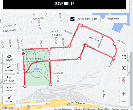
mapmyrun.com is another free online jogging route planner website. This website offers an interactive world map on which users can open up any specific location and plan a jogging route. It also supports multiple map views (Terrain, Satellite, Hybrit, OpenStreet, etc.) that users can select before planning a route. To plan a route, users need to add multiple points along a path on the map. Each new dot will connect with the previous dot to indicate the jogging path. To create a closed route path, users need to select the Loop route at this point option.
This website also offers options to show Elevation, Traffic, and Bike Paths on your planned route. In the end, users can preview the route and save it in GPX and KML file formats. Although, the print route feature is only available to premium users. Now, check out its main features.
Main Features:
- Multiple Map View Support: This website supports multiple map views such as Terrain View, Satellite View, Hybrid View, OpenStreet View, World Topo, etc.
- Simple Route Planner: To plan a route, users need to add dot marks over a path to specify the jogging route. To add a dot, users just need to click on a specific location.
- Route Planning Tools: It offers useful tools like Return (take the shortest path), Flip (Flip the start and end points), Out + Back (Take the same path back to start), Undo, etc.
- Display: This tool can display various important information related to the planned route such as elevation, traffic, and bike paths.
- Save: Users can save the planned jogging route in GPX and KML file formats.
Additional Features:
- This website also helps users track the jogging distance, duration of jogging, and calories burnt during jogging.
Final Thoughts:
It is another good online jogging route planner website through which users can plan jogging routes and keep track of their jogging activities.
| Pros | Cons |
|---|---|
| Supports multiple types of map views | Its free version doesn’t allow users to print the jogging route |
| Lets users save the planned jogging route in GPX and KML formats |
komoot.com

komoot.com is another free online jogging route planner website. This website offers a simple route planner tool through which users can plan jogging routes, hiking routes, biking routes, etc. To plan a jogging route, it offers an interactive map on which users can open up a location and mark the route on which they want to jog. After marking the jogging route, users can specify it as One Way or Round Trip. It also shows the length and elevation information of the marked jogging path. Although, it only supports two map types in its free version namely Komoot Map (Street View) and Satellite Map. After finalizing the jogging route, users can save it within this website that users can later access and view. Now, check out the main features.
Main Features:
- Route Planner: The route planner allows users to easily select the path over a map on which they want to jog.
- Route Information: This website immediately shows various details about a selected route like its length, time to run the route, elevation at different parts of the route, paved route length, unpaved route length, etc.
- Device Integration: Komoot app for both Android and iOS devices is available on which users can send the planned jogging routes.
- Save Tour: It lets users save the planned routes within this website that users can later access and edit if they want.
Final Thoughts:
It is another good online jogging route planner website that offers all the essential tools to create and edit jogging, cycling, and running routes.
| Pros | Cons |
|---|---|
| Can also be used to make cycling and running routes | Its free version only offers two map types |
| Lets users send the planned routes to iOS and Android Komoot app |
goodrunguide.co
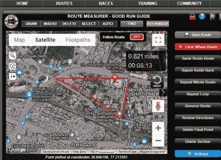
goodrunguide.co is another free online jogging route planner website. This website comes with a simple route planner and measurement tool through which users can plan their jogging route. It also supports Street View Map, Satellite Map, and Footpath map views. The Footpath map is especially beneficial as it helps users find the routes with footpaths on which users can jog.
The process of specifying the jogging route over a map is also quite simple. To do that, users need to add multiple dots along with a path on the map on which they want to jog. The assigned dots will connect and show the jogging path over a map. It also offers multiple route editing tools like Same route home, rejoin route back, Reverse route, etc. The free version of this website doesn’t let users save or bookmark the route. Now, check out its main features.
Main Features:
- Map Types: This website supports three types of maps namely Street View, Satellite View, and Foothpath.
- Draw Route: By pacing the dots over a map, users can specify the jogging path with ease. Plus, a good set of path editing tools are offered by it like repeat loop, rejoin route back, same route home, etc.
- Auto Route: It s another good feature that automatically creates a path based on the starting and destination location plots.
- Route Distance and Time: This website also shows the distance of a planned route along with the time to cover the route.
Additional Features:
- This website also comes with additional tools like Browse UK Race Diary, Training Planner, Goal Tracker, Weight Tracker, etc.
Final Thoughts:
It is another good online jogging route planner website through which users can plan a jogging route over footpath, satellite, and street view maps.
| Pros | Cons |
|---|---|
| Can also calculate the planned route distance | Its free version doesn’t let users save the jogging route |
| Offers a handy auto-route feature |
routeyou.com
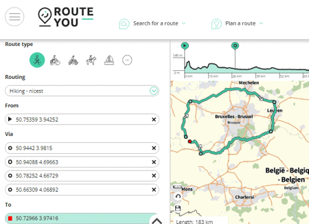
routeyou.com is another free online jogging route planner website. Using this website, users can quickly plan a jogging route. To do the planning, users can use the interactive map on which they can open up any part of the world. After that, users can add multiple points around a path on the map to specify the entire jogging route. This website automatically calculates the length of the planned route along with elevation data. Although, the free version of this website restricts users from using Satellite View Map and Google Maps. Now, check out its main features.
Main Features:
- Route Planner: This website offers a simple route planner through which users can quickly specify the jogging route path over an interactive map. A good set of route editing tools (Invert Route, Split Route, Change Starting Point) are also provided by it.
- Elevation Profile: It shows the change in elevation over the entire planned jogging route.
- Maps: This website offers multiple interactive map types like OpenStreet Map, Topo Map, etc. Besides this, it also lets users add Hicking Nodes, Cycling Nodes, GR network Nodes, and Road Properties over the map.
- Save: This website lets users save the final planned jogging route in GPX format. Besides this, it also lets users generate the route path for various devices like Garmin, Mio, Teasi, etc.
Additional Features:
- This website also shows the attractions and places near your plotted jogging route.
- It also offers Android and iOS apps that allow users to plan a jogging route on their smartphones.
Final Thoughts:
It is another good online jogging route planner website that anyone can use without much hassle.
| Pros | Cons |
|---|---|
| Offers all necessary route planning tools | Its free version doesn’t restrict some maps from users |
| Supports multiple maps |
footpathapp.com
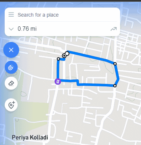
footpathapp.com is another free online jogging route planner website. It is another good website that offers an interactive street view map on which users can plot and plan their jogging route. To create a jogging route over the street view map, users need to click on the map and choose the Route to here option. By placing multiple points around a route on the map, users can specify a jogging route.
This website also shows the length of the route and the elevation values of the entire route. In between a route, users can also specify multiple waypoints if they want. Although, it lacks a multiple map view feature, unlike most other similar websites. By creating an account on this website, users can save the route on its server that users can later access. Now, check out the main features.
Main Features:
- Simple Route Planning: This website offers one of the simplest route planners that anyone can use to quickly mark a jogging route over an interactive street view map.
- Overview: It shows the length of the route and elevation at different parts of the route.
- Save: Users can save the jogging route within this website that they can access layer.
Final Thoughts:
It is one of the simplest online jogging route planner websites using which users can plan their jogging route over an interactive street view map.
| Pros | Cons |
|---|---|
| Lets users save up to 5 routes on its server | The free version of this website only allows users to save a limited number of routes |
| Only support one map type (street view) |
routesshuffle.com
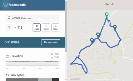
routesshuffle.com is another free online jogging route planner website. Using this website, users can plan jogging or running, walking, and biking routes. On its OpenStreen interactive map, users can open up any location and mark a location as the starting point. After that, specify the distance of the jogging route. Next, click on the make route button to view a jogging route of a specified distance. Now, to make another variant of the jogging route click on the Remake route button. It also provides an Elevation graph highlighting the change in elevation at different parts of the jogging route. The created jogging route can also be shared with others in the form of a link. The feature to save and export the route is only available to premium users. Now, check out the main features.
Main Features:
- Auto Route Planner: This website uses the specified starting location over the map and the distance of the route to automatically create a jogging route. To change the jogging route, users use its remake route option.
- Elevation Graph: It shows the route elevation values at different parts of the jogging route.
- Route Type: Users can create running or jogging, walking, and cycling routes through this website.
Final Thoughts:
It is a simple online jogging route planner website that can automatically create a jogging route using a starting location and jogging distance.
| Pros | Cons |
|---|---|
| Can automatically create a jogging route | Free version of this website doesn’t let users save and export routes |
map-planner.com

map-planner.com is the last free online jogging route planner website. This website is mainly used to calculate the distance of a specific route. Although, it offers all the necessary tools to plan a jogging route. It also offers a search tool to find any location on the world map using its name. After opening a specific location over its interactive street map, users can specify start and end route points. Users can also adjust in-between route points to select a specific jogging path. Now, users can view the distance of the route along with elevation data. Now, check out its main features.
Main Features:
- Street View Map: This website offers an interactive street view map on which users can open up any part of the world and start creating a route.
- Simple Route Planning: To plan a jogging route, users need to specify starting and ending points. After which, users can adjust the path that connects the two points.
- Route Information: Users will get the planned route distance and elevation values at different points of the route.
- Export: After creating an account on map-planner.com, users can export the created route as a GPX file.
Final Thoughts:
It is another good online jogging route planner website through which users can plan jogging routes with ease.
| Pros | Cons |
|---|---|
| Offers a simple route planning tool | Only supports street view map |
| Les users export the planned route as a GPX file |
Frequently Asked Questions
You can use above mentioned jogging route planner websites to plan a run route. These websites comes with interactive maps on which you can open up any city of the world. After locating a specific city, you can mark the routes on which you want to run. These websites will automatically calculate the marked route distance and show the changes in route elevation.


Naveen Kushwaha
Passionate about tech and science, always look for new tech solutions that can help me and others.
About Us

We are the team behind some of the most popular tech blogs, like: I LoveFree Software and Windows 8 Freeware.
More About UsArchives
- May 2024
- April 2024
- March 2024
- February 2024
- January 2024
- December 2023
- November 2023
- October 2023
- September 2023
- August 2023
- July 2023
- June 2023
- May 2023
- April 2023
- March 2023
- February 2023
- January 2023
- December 2022
- November 2022
- October 2022
- September 2022
- August 2022
- July 2022
- June 2022
- May 2022
- April 2022
- March 2022
- February 2022
- January 2022
- December 2021
- November 2021
- October 2021
- September 2021
- August 2021
- July 2021
- June 2021
- May 2021
- April 2021
- March 2021
- February 2021
- January 2021
- December 2020
- November 2020
- October 2020
- September 2020
- August 2020
- July 2020
- June 2020
- May 2020
- April 2020
- March 2020
- February 2020
- January 2020
- December 2019
- November 2019
- October 2019
- September 2019
- August 2019
- July 2019
- June 2019
- May 2019
- April 2019
- March 2019
- February 2019
- January 2019
- December 2018
- November 2018
- October 2018
- September 2018
- August 2018
- July 2018
- June 2018
- May 2018
- April 2018
- March 2018
- February 2018
- January 2018
- December 2017
- November 2017
- October 2017
- September 2017
- August 2017
- July 2017
- June 2017
- May 2017
- April 2017
- March 2017
- February 2017
- January 2017
- December 2016
- November 2016
- October 2016
- September 2016
- August 2016
- July 2016
- June 2016
- May 2016
- April 2016
- March 2016
- February 2016
- January 2016
- December 2015
- November 2015
- October 2015
- September 2015
- August 2015
- July 2015
- June 2015
- May 2015
- April 2015
- March 2015
- February 2015
- January 2015
- December 2014
- November 2014
- October 2014
- September 2014
- August 2014
- July 2014
- June 2014
- May 2014
- April 2014
- March 2014
