5 Best Free GeoTIFF Viewer Software For Windows
Here is a list of best free GeoTIFF viewer software for Windows. GeoTIFF i.e. Georeferenced Tagged Image File Format is a public domain metadata standard that allows TIFF files to embed georeferencing data. Georeferencing data basically means maps, coordinates, projection, datum, etc. In order to view and analyze GeoTIFF files, you need a GeoTIFF viewer software. These software not only show GeoTIFF data but also provide various analysis and editing tools.
Using these software, you can view the visual data or map present in GeoTIFF files. To highlight parts of the map, you get RGB, Raster, Vector, etc. tools. The RGB tool is really handy as it allows you to manually adjust map color profiles to highlight its boundaries. It is also quite easy to zoom in, pan, or rotate maps in these software to get a better perspective. Along with maps, you can also easily view Longitude, Latitude, Coordinates, Geographical Information, etc. through some of these GeoTIFF Viewers.
My Favorite GeoTIFF File Viewer Software For Windows:
CARIS Easy View is my favorite software because it shows GeoTIFF visual map along with all the associated metadata. It also provides various map analyzing tools which is another advantage of this software.
You can also check out lists of best free Video Metadata Viewer, GIS Data Viewer, and Shapefile Viewer software for Windows.
CARIS Easy View
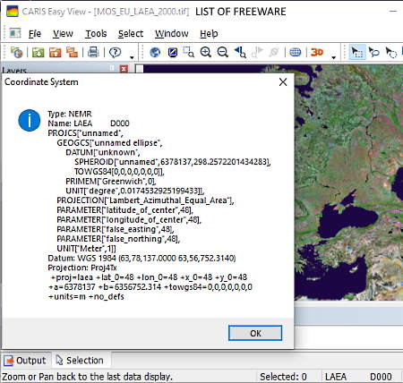
CARIS Easy View is a free GeoTIFF viewer software for Windows. In this software, you can load and view both locally stored and cloud-stored GeoTIFF files. In it, you can view the visual geographical map and all associated metadata. To properly view the map, it provides tools like Zoom Selected Area, Channels (to change Red, Green, and Blue color profiles of the map), Measure Distance and Angle, Image Transparency, etc. A full-screen mode to analyze the map without any distraction is also available in it. To view the metadata and coordinates information, go to its Properties > General and click on the three-dot button of Coordinate system row. By pressing the three dot button, you can view all associated data like Projection, Units, Coordinates, Latitude Centre, Longitude Centre, etc.
Besides GeoTIFF, this software supports a wide range of chart formats, including CARIS, S-57, ENC, Inland ENC, and VPF vector data formats. Plus, you can access data of BSB, HCRF, TIF/IGA, TIF/TFW, etc. file formats through this software. After viewing and analyzing the data of GeoTIFF or other supported files, you can save the whole session, directly print map, or save the visual part of the data in PDF file format.
QGIS
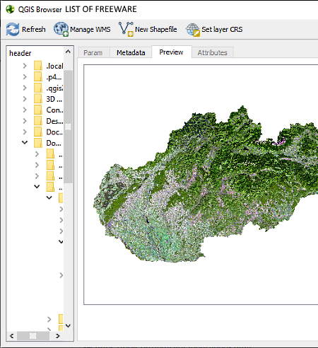
QGIS is a free GeoTIFF Viewer Software for Windows. This software shows both the visual map along with all the metadata present in a GeoTIFF file. In it, you can also perform a visual analysis of the map using dedicated Vector and Raster tools like Mean Coordinate Line Intersection, Distance Matrix, Grid, Raster Distance, etc. Besides analysis, you can also edit and add Raster, Vector, PostGIS, WCS, etc. layers through this software. To view all the geolocation data that comes with GeoTIFF file, you can use its Metasearch and Open Attribute options. It also allows you to extract coordinates of any location present in the map by just pointing the cursor over a location.
In this software, you also get various standard tools which help in visual analysis like Zoom in/out, Measure, Zoom To Layer, Pan Map, and more. In general, it provides all essential tools to view, analyze, and edit GeoTIFF file information. After viewing and editing, you can save the file as QGIS File or export as DXF file.
FreeView
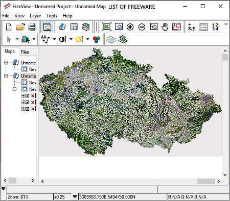
FreeView is another free GeoTIFF viewer software for Windows. Using this software, you can view and analyze GeoTIFF file. Apart from GeoTIFF, it also supports various Raster and Vector formats, Shape Files, AutoCAD Files, etc.
In it, you can open GeoTIFF file of any size which is that main advantage of this software. Now, to view and analyze GeoTIFF file, it provides various tools like Zoom, Named Region (to view a specific region), Contrast (to clearly view boundary details), etc. To view the metadata present in the GeoTIFF file, it provides a dedicated Attribute Manager feature. However, during the testing, this feature does not seem to be working correctly.
In this software, you can also change the color profile of the map using Histogram and RGB mapper tools. After viewing and analyzing GeoTIFF file, you can directly print the map contained in GeoTIFF file or save it as PDF file.
TatukGIS Viewer
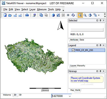
TatukGIS Viewer is the next free GeoTIFF viewer software for Windows. As its name implies, it is mainly a GIS data viewer software that displays both visual and geographical data present in a GIS file. Similar to GIS file, it can also show you the visual map present in a GeoTIFF file. However, it does not show the geographical data of a GeoTIFF file which is its main limitation. It is still quite a decent software for viewing and analyzing a geographical map of a GeoTIFF file. For the analysis, you can use its Measure, Full Extent, Zoom, etc. tools. A handy full-screen mode to view the map without any distraction is also available in it.
In this software, you can also edit geographical maps, that you can also save for later use. For editing, it provides tools like line, polygon, rectangle, circle, etc. The main advantage of this software is that it can handle large GeoTIFF data files because of its use of R-tree indexing.
This software also provides facility to access and view your GIS and GeoTIFF data from any server by providing the server address. After viewing or editing the data, you can save it as PDF or as TatukGIS project file.
ER Viewer
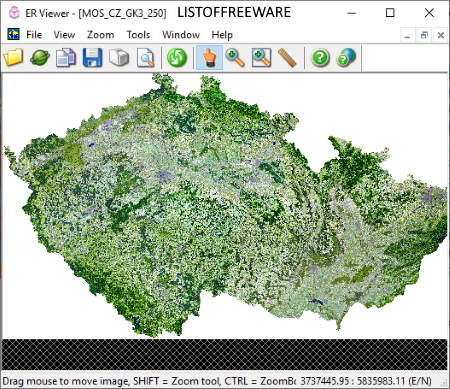
ER Viewer is yet another free GeoTIFF Viewer software for Windows. It is a simple GeoTIFF viewer software in which you can view and analyze geographical map present in a GeoTIFF file. Besides this, it supports all common image formats. It shows the fully colored map that you can easily zoom to view all the fine details of the geographical area. With this software, you can also measure the distance between any two points over the map using its Measure Tool. Along with locally stored GeoTIFF file, you can open any online GeoTIFF file by providing the URL of a GeoTIFF file to this software.
This software can surely open and show you a GeoTIFF file, but important features like Metadata Viewer, RGB Controller, Support For Layers, etc. are not present in it. In general, it is a basic GeoTIFF viewer that only shows the visual part of a GeoTIFF file.


Naveen Kushwaha
Passionate about tech and science, always look for new tech solutions that can help me and others.
About Us

We are the team behind some of the most popular tech blogs, like: I LoveFree Software and Windows 8 Freeware.
More About UsArchives
- May 2024
- April 2024
- March 2024
- February 2024
- January 2024
- December 2023
- November 2023
- October 2023
- September 2023
- August 2023
- July 2023
- June 2023
- May 2023
- April 2023
- March 2023
- February 2023
- January 2023
- December 2022
- November 2022
- October 2022
- September 2022
- August 2022
- July 2022
- June 2022
- May 2022
- April 2022
- March 2022
- February 2022
- January 2022
- December 2021
- November 2021
- October 2021
- September 2021
- August 2021
- July 2021
- June 2021
- May 2021
- April 2021
- March 2021
- February 2021
- January 2021
- December 2020
- November 2020
- October 2020
- September 2020
- August 2020
- July 2020
- June 2020
- May 2020
- April 2020
- March 2020
- February 2020
- January 2020
- December 2019
- November 2019
- October 2019
- September 2019
- August 2019
- July 2019
- June 2019
- May 2019
- April 2019
- March 2019
- February 2019
- January 2019
- December 2018
- November 2018
- October 2018
- September 2018
- August 2018
- July 2018
- June 2018
- May 2018
- April 2018
- March 2018
- February 2018
- January 2018
- December 2017
- November 2017
- October 2017
- September 2017
- August 2017
- July 2017
- June 2017
- May 2017
- April 2017
- March 2017
- February 2017
- January 2017
- December 2016
- November 2016
- October 2016
- September 2016
- August 2016
- July 2016
- June 2016
- May 2016
- April 2016
- March 2016
- February 2016
- January 2016
- December 2015
- November 2015
- October 2015
- September 2015
- August 2015
- July 2015
- June 2015
- May 2015
- April 2015
- March 2015
- February 2015
- January 2015
- December 2014
- November 2014
- October 2014
- September 2014
- August 2014
- July 2014
- June 2014
- May 2014
- April 2014
- March 2014
