6 Best Free Coronavirus Map Software For Windows
Here is a list of best free coronavirus map software for Windows. Through these software, you can track the number of growing cases of coronavirus pandemic all over the world. To track the coronavirus pandemic, these software offer an interactive world map with hotspots highlighting affected countries and their cases. By clicking over a hotspot of a country, you can view the total number of affected people, deaths, active cases, and recovered people. You can also pan and zoom in on the map to view analyze affected countries in detail. In some software, you can also view the data of previous dates by moving the date seekbar to previous dates. It helps you analyze how quickly this pandemic is growing each day.
Apart from an interactive map, these coronavirus map software also offer graphs and lists to give you more insight about this pandemic. Through graphs, you can track the exponential growth of deaths and new cases over time. Through lists, you can view country-wise data of affected people. From some software, you can also download graphs and lists in PNG, PDF, XLS, etc., formats. In some software, you can also view US-specific data such as number of affected US counties, affected people in each county, interactive county map, etc. Go through the list to know more about these software.
My Favorite Coronavirus Map Software For Windows:
coronavirus-map is my favorite software because it offers the most detailed multi-layered interactive coronavirus world map. Through its interactive map, you can track the number of confirmed cases, deaths, and recovered people of all affected countries. Plus, it also offers multiple graphs and lists to give you additional information about this pandemic.
You can also check out lists of best free Coronavirus Monitoring Tools, Hurricane Tracking, and Patient Management software for Windows.
coronavirus-map
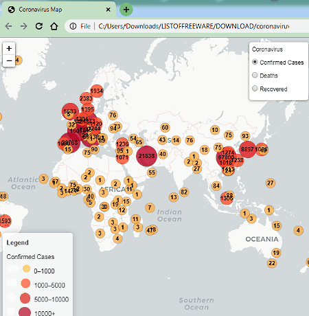
coronavirus-map is a free open source coronavirus map software for Windows. To run this software, you need a web browser as it is as web-based software. In this software, you can view an interactive world map highlighting countries affected by coronavirus with circles with colors and numbers. The size and color of a circle over a country indicate the number of detected cases/ recovered people/ deaths. In addition to that, it offers a collapsible side menu containing multiple graphs and statistics about different countries. To keep this map updated the researchers of John Hopkin’s Medicine regularly update its information. Now, check out the main features of this software.
- Multi-Layered Interactive Map: This interactive map of this software built using three layers namely number of confirmed cases, deaths, and recovered. You can select one layer at a time to view statistics related to that layer over the world map. To closely analyze individual countries over the map, it also offers the zoom and pan functionality.
- Graphs: To help you understand the exponential spread of this virus, this software offers multiple graphs showing growth of deaths by country and growth of confirmed cases by country over time. It also lets you save graphs in PNG, JPG, PDF, SVG, CSV, and XLS formats.
- Coronavirus Statistics: In the side panel of this software, you can view various statistics such as top countries with highest daily increase in number of deaths, countries with the highest daily percentage change in deaths, countries that most recently announced the first deaths within their borders, and more.
Final Thoughts:
It is one of the best free coronavirus map software shows that provides the most detailed coronavirus statistics, graphs, and interactive map.
COVID-19 TRACKER
COVID-19 TRACKER is a free coronavirus map extension for Google Chrome. This extension shows a world map highlighting all the countries affected by this coronavirus pandemic. Countries that are severely impacted are highlighted in dark colors, while less affected countries are highlighted in light colors. In addition to that, a table showing the country-wise coronavirus statistics like the number of infected people, number of deaths, and number of recovered people are also present in it. Now, check out the main features of this extension.
Main Features:
- Interactive Map: This extension offers an interactive map on which you can zoom in and select a specific country to view its coronavirus statistics.
- Statistics Table: In it, you can view a list of all the countries which are affected by the coronavirus along with the number of affected people, total deaths, and recovered people.
This extension shows the most recent statistics on which you can rely upon.
Final Thoughts:
It is another good coronavirus map extension that shows all the important coronavirus information over an interactive map.
coronavirus-tracker
coronavirus-tracker is another free open source coronavirus map software for Windows. It is a web-based software that needs a web browser to work. This software provides an interactive world map highlighting the number of confirmed cases and deaths in different countries by the coronavirus pandemic. To highlight coronavirus cases over the map, it uses red circles of varying sizes. As the number of cases and deaths increases in a country, the size of red circle will also increase. The unique thing about this software is its ability to shows detected cases and deaths of previous dates. To do that, it provides a date seek bar at the bottom of the interactive map. Now, check out the main features of this software.
Main Features:
- Interactive World Map: It is the main feature of this software that lets you zoom and pan the world map so that you can view the number of coronavirus cases in different countries.
- Highlighting Red Circle: It is another important feature of this software that helps users to quickly identify most affected countries of the world.
- Worldwide Total: It shows the total number of confirmed cases, deaths, and mortality rate on a given date.
Final Thoughts:
It is another easy to use coronavirus map software to track the number of coronavirus affected people in different countries.
coronavirus-time-series-map
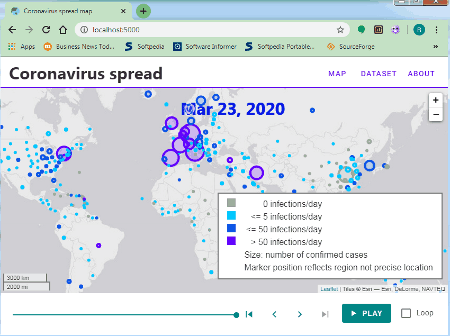
coronavirus-time-series-map is the next free open source coronavirus map software for Windows. Through this software, you can track the number of people affected by the coronavirus in different countries over time. To do that, it offers an interactive coronavirus infection map highlighting all countries with circles of different colors and sizes. The color of a circle indicates the number of new cases in a day. On the other hand, the size of the circle shows the total number of cases in a country. Now, to track the coronavirus cases on previous dates, you can use the date seekbar.
Main Features:
- Interactive Map: On the interactive map of this software, you can view all the coronavirus affected countries and number of cases of those countries. As it offers an interactive map, thus, you can easily pan and zoom in on the map.
- Highlighting Circles: This feature allows you to quickly identify the most affected countries of the world.
- Date Seekbar: Using it, you can view the number of cases of coronavirus cases on different countries on previous dates.
Note:
To use this software, you need to follow some steps. First, download and install the Node.js to your system. After that, go to the main folder of this software and open up the command prompt. Next, write this command npm install and press enter. After that, write and run this command npm run dev. Lastly, open up your web browser and paste http://localhost:5000 in the address bar and press Enter key to start this software.
Final Thoughts:
It is another good coronavirus map software that shows important statistics about coronavirus over the interactive world map.
COVID-19 - CoronaVirus for Chrome
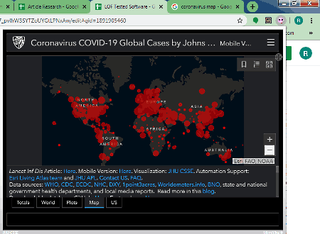
COVID-19 – CoronaVirus for Chrome is a free coronavirus map for Chrome. It is a Chrome extension that shows various statistics, graphs, and a map about coronavirus affected areas. You can quickly access it from the toolbar and immediately view the latest statistics of affected people in different countries, number of death, number of recovered people, etc. Now, check out the main features of this software.
Main Features:
- Map: This software offers an interactive map showing hotspots of coronavirus cases all over the world. By selecting a hotspot (red circle) of a country, you can view its active cases, deaths, confirmed cases, and recovered cases.
- Plots: It shows a bar graph and dot plot graph showing the exponential growth of coronavirus cases over time.
- World Lits: It shows a list of countries with the number of coronavirus cases in them.
- Totals: It gives an overview of the total number of coronavirus cases all over the world, total number of deaths, and the total number of affected countries.
- US: It only shows the state-wise coronavirus cases in the United States.
Final Thoughts:
It is an informative coronavirus map extension through which you can track coronavirus statistics of all affected countries.
COVID-19-US-county-map
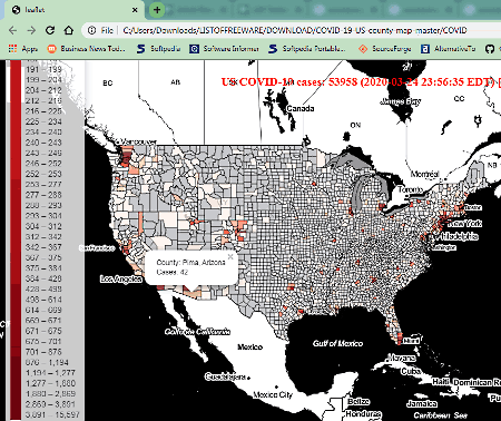
COVID-19-US-county-map is yet another free open source coronavirus map software for Windows. As its name suggests, it only shows coronavirus cases identified in US counties. This software covers all 3007 US counties. To show you the affected counties, it provides an interactive map with different shades of red along with the number of detected cases. By hovering the cursor over a county, you can find out its name and number of detected coronavirus cases in it. Let’s take a look at some of the main features of this software.
Main Features:
- Interactive Map: You can easily pan and zoom in over the county map to closely view small counties and find out the number of detected coronavirus cases in them.
- County Color Shades: The color shades of each county helps users to immediately find out the hotspots of coronavirus cases. It is also quite helpful to find out counties that are least or not affected at all by the coronavirus.
Limitation:
- This software does not show any information related to deaths and recovered people. Plus, it does not include any country other than the United States.
Final Thoughts:
It is a handy coronavirus map software if you only want to find out the county wise coronavirus cases in the United States.


Naveen Kushwaha
Passionate about tech and science, always look for new tech solutions that can help me and others.
About Us

We are the team behind some of the most popular tech blogs, like: I LoveFree Software and Windows 8 Freeware.
More About UsArchives
- May 2024
- April 2024
- March 2024
- February 2024
- January 2024
- December 2023
- November 2023
- October 2023
- September 2023
- August 2023
- July 2023
- June 2023
- May 2023
- April 2023
- March 2023
- February 2023
- January 2023
- December 2022
- November 2022
- October 2022
- September 2022
- August 2022
- July 2022
- June 2022
- May 2022
- April 2022
- March 2022
- February 2022
- January 2022
- December 2021
- November 2021
- October 2021
- September 2021
- August 2021
- July 2021
- June 2021
- May 2021
- April 2021
- March 2021
- February 2021
- January 2021
- December 2020
- November 2020
- October 2020
- September 2020
- August 2020
- July 2020
- June 2020
- May 2020
- April 2020
- March 2020
- February 2020
- January 2020
- December 2019
- November 2019
- October 2019
- September 2019
- August 2019
- July 2019
- June 2019
- May 2019
- April 2019
- March 2019
- February 2019
- January 2019
- December 2018
- November 2018
- October 2018
- September 2018
- August 2018
- July 2018
- June 2018
- May 2018
- April 2018
- March 2018
- February 2018
- January 2018
- December 2017
- November 2017
- October 2017
- September 2017
- August 2017
- July 2017
- June 2017
- May 2017
- April 2017
- March 2017
- February 2017
- January 2017
- December 2016
- November 2016
- October 2016
- September 2016
- August 2016
- July 2016
- June 2016
- May 2016
- April 2016
- March 2016
- February 2016
- January 2016
- December 2015
- November 2015
- October 2015
- September 2015
- August 2015
- July 2015
- June 2015
- May 2015
- April 2015
- March 2015
- February 2015
- January 2015
- December 2014
- November 2014
- October 2014
- September 2014
- August 2014
- July 2014
- June 2014
- May 2014
- April 2014
- March 2014
