5 Best Free Meteorological Software For Windows
This article contains a list of Best Free Meteorological Software for Windows. These software are useful meteorologists or aspiring meteorologist to study and analyze weather forecast data. You can analyze various atmospheric parameters for a location to study various weather events using these. To know more about meteorology, check this link.
In these software, you can analyze old meteorological data or even new ones. You just have to import dataset in a supported format and then use various tools to study meteorological characteristics. To perform analysis, these free software provide various results table and graphs which contain calculations like radiation, precipitation, sunshine duration, temperature, frequency distribution, estimated actual velocity, time of arrival, etc. A few of these software are used to study wind climate, wind rose plot, etc. As graphs, you get area, bar, histogram, points, scatter plot, ribbon, spline, and other graphs for calculated parameters.
All in all, these are nice free software to analyze meteorological data for the study of weather events. Go through this list to find a software as per your requirements.
My Favorite Free Meteorological Software For Windows:
Meteonorm is one of my favorite software as it is featured yet very easy to use software which provides a straightforward approach to perform analyses. AWIPS CAVE is another feature rich meteorological software which can be used by professionals.
You may also like some best free Weather Software, Satellite Tracking Software, and Hurricane Tracking Software for Windows.
Meteonorm
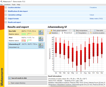
Meteonorm is a nice free meteorological software for Windows. It lets meteorologist access historical time series of irradiation and temperature. You get a location database using which you can perform analysis on a specific location to calculate and study various meteorological parameters. These parameters include radiation, precipitation, sunshine duration, temperature, etc. If you want, you can also add a custom location to perform a meteorological study.
Features:
- To add a custom location, you can import a location file.
- You can add a location to the favorites list to quickly use it in the future.
- You can view a location on the map and also view related details.
- It shows charts as results and you also get a data table with values of different weather parameters.
- It provides its own meteorological data which you can use for calculation. Apart from that, you can import external meteorology dataset too.
How Meteonorm works:
This software is comparatively quite simple to use as you have to perform step by step procedure as given on its main interface. Those steps are:
- Choose a location from its inbuilt location database.
- Setup data import settings which basically include plane orientation, atmospheric turbidity, horizon, download time series, etc.
- Configure calculation settings like dataset, period radiation, period temperature, etc.
- Select output format such as Polysun, humidity, science, spectral/ UV, TSOL, etc.
- Now, you can view results in its “Results and export” section.
Limitation:
This free version (demo version) of Meteonorm doesn’t let you save the output.
Conclusion:
In my opinion, it is one of the best meteorological software for someone who is a beginner. It is extremely easy to use and works effortlessly.
AWIPS CAVE
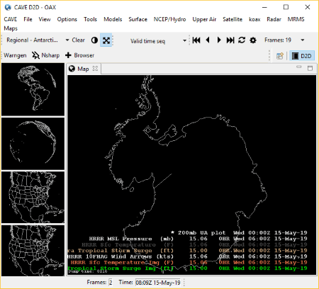
AWIPS CAVE is a featured meteorological software for Windows. It is developed by National Weather Service and Raytheon for the study of various meteorological parameters. You can analyze meteorological data for various locations in it.
This software is suitable for professionals as it contains a number of tools which require expertise to be understood.
Highlights of AWIPS CAVE:
- It contains a Model menu which provides a variety of numerical model and other data sources for analysis, such as GFS, HRRR, NAM, NAVGEM, RTMA, URMA, etc.
- It offers various different maps, views, and projections. The default view is CONUS which can be changed to other views.
- You get upper air plots, CPC plots, VWP height-level plots, MDCRS plots, and more in it.
- It contains a lot of tools to measure and study various factors like Distance Scale, Distance Speed, Distance Bearing, Sunrise/ Sunset, Estimated Actual Velocity, Time of Arrival, VR-Shear, etc.
- It provides some handy features such as Nsharp Editor, WarnGen Walkthrough, D2D Perspective, Volume Browser, etc.
- It lets you import geospatial data from local files like GeoTIFF, SPI, LPI, etc.
- It also provides satellite and radar tools to perform meteorological data analysis, like GOES-16, GOES-17, NEXRAD Stations, TDWR Stations, etc.
- You get some more additional utilities in it to some more weather forecast and atmospheric related studies, such as Hurricane Tracker, Sounding-derived plots, CPC Hazard Charts, Tropical Surface Analysis, Fire Weather, QPF, etc.
- You can also compute and study various surface related parameters including surface temperature, surface winds, METAR station plots, Flood/ Wind/ Marine Watches, Warnings, and Advisories, Geostationary Lightning Mapper, etc.
These were some of the features of AWIPS CAVE. In actual, it contains a lot more tools and features which can be used to carry out meteorological study.
Conclusion:
It is one of the best software for analyzing meteorological data which is well suited for professionals.
WRPLOT View
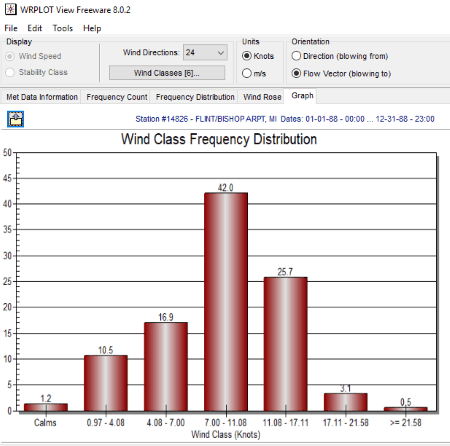
WRPLOT View is one more free meteorological software for Windows. It lets you perform frequency analysis and lets you visualize wind rose and other plots for your meteorological data.
Main Features:
- It lets you import meteorological datasets from a locally stored file. For that, it supports DAT, TXT, CSV, MET, SAM, SFC, and some other file formats.
- It provides an option to import surface data from an Excel file.
- When you import a dataset, it displays various data information like average wind speed, calm winds frequency, data availability, etc.
- For meteorological data study, you can customize wind directions, orientation (blowing to/from), date range, station name, etc.
- You can view results in respective tabs which include frequency counts, frequency distribution, wind rose plot, and wind class distribution graphs (area, bar, histogram, points+best fit curve, ribbon, spline, etc.).
- You can also view, edit, and manage wind classes and wind rose sectors.
- It lets you customize wind rose plot display and also allows you to export rose plot for a location.
- It lets you save the analysis report as a TXT file.
- You can also print frequency report and wind rose graphs.
Conclusion:
It is a handy software to study existing meteorological data with the help of frequency distribution and wind rose charts.
MeteoInfo
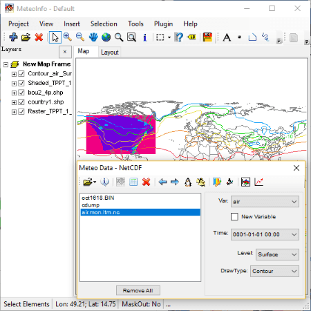
MeteoInfo is yet another free meteorological software for Windows. It lets you visualize and analyze meteorological data. It also lets you perform analysis on spatial data.
Main Features:
- It supports meteo datasets in various formats which include GrADS binary grid and station data, NetCDF, GRIB data, HDF5 EOS5 data, and MICAPS data.
- You can find a few sample data to perform meteorological analysis in it.
- It lets you view station data contained in an imported dataset.
- It lets you draw imported meteorological datasets on graphs including section plot and one dimension plot.
- It lets you change projection of map such as orthographic, geostationary, Mercator, sinusoidal, etc.
- You get some more tools in it like Point Projection, Join Data, MICAPS to GrADS, etc.
How to perform meteorological analysis with this free software:
Simply import a supported dataset using the dedicated option. After that, select variable, time, level, and draw type and then click on Draw Data button to visualize it on the map. Similarly, you can draw section or one dimensional plot.
Conclusion:
It is a decent meteorological software using which you can study and analyze existing meteorological datasets.
WAsP Climate Analyst
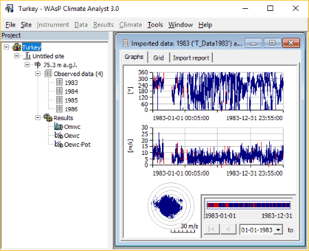
WAsP Climate Analyst is the next free meteorological software for Windows. It is basically used for the analysis of time series of wind measurement which basically gives statistics related to wind climate.
How to use WAsP Climate Analyst:
Firstly, add a site location by providing its GPS coordinates. Now, by right clicking on the site, you can import datasets in formats like DAT, CSV, TXT, etc. You can also add an instrument (as data collection devices) with specific height. After that, from the Results menu, you can generate Observed Mean Wind Climate (OMWC) or Observed Extreme Wind Climate – Points Over Threshold (OEWC – POT) report using the respective button. It shows you results in forms of the climate data graph, climate data table, climate generation report, all sectors statistics, etc. You can view results with wind climate and respective power and quality.
To compute OMWC or OEWC results, it lets you edit some specifications including count of sectors, velocity bin width, etc.
If the dataset is not correct, it will display a “cannot be computed” message in Results menu.
Conclusion:
It is a nice free software to analyze wind climate.
About Us
We are the team behind some of the most popular tech blogs, like: I LoveFree Software and Windows 8 Freeware.
More About UsArchives
- May 2024
- April 2024
- March 2024
- February 2024
- January 2024
- December 2023
- November 2023
- October 2023
- September 2023
- August 2023
- July 2023
- June 2023
- May 2023
- April 2023
- March 2023
- February 2023
- January 2023
- December 2022
- November 2022
- October 2022
- September 2022
- August 2022
- July 2022
- June 2022
- May 2022
- April 2022
- March 2022
- February 2022
- January 2022
- December 2021
- November 2021
- October 2021
- September 2021
- August 2021
- July 2021
- June 2021
- May 2021
- April 2021
- March 2021
- February 2021
- January 2021
- December 2020
- November 2020
- October 2020
- September 2020
- August 2020
- July 2020
- June 2020
- May 2020
- April 2020
- March 2020
- February 2020
- January 2020
- December 2019
- November 2019
- October 2019
- September 2019
- August 2019
- July 2019
- June 2019
- May 2019
- April 2019
- March 2019
- February 2019
- January 2019
- December 2018
- November 2018
- October 2018
- September 2018
- August 2018
- July 2018
- June 2018
- May 2018
- April 2018
- March 2018
- February 2018
- January 2018
- December 2017
- November 2017
- October 2017
- September 2017
- August 2017
- July 2017
- June 2017
- May 2017
- April 2017
- March 2017
- February 2017
- January 2017
- December 2016
- November 2016
- October 2016
- September 2016
- August 2016
- July 2016
- June 2016
- May 2016
- April 2016
- March 2016
- February 2016
- January 2016
- December 2015
- November 2015
- October 2015
- September 2015
- August 2015
- July 2015
- June 2015
- May 2015
- April 2015
- March 2015
- February 2015
- January 2015
- December 2014
- November 2014
- October 2014
- September 2014
- August 2014
- July 2014
- June 2014
- May 2014
- April 2014
- March 2014
