6 Best Free TCX Viewer Software For Windows
Here is a list of best free TCX viewer software for Windows. These software let you view a TCX file (Training Center XML file) which contains tracks, track points, and other GPS information. Most of these software show track data on the map using various map services such as OpenStreet, OpenCycleMap, MapQuest (Satellite), 4UMap, HikeBikeMap, Thunderforest, OpenTopoMap, ArcGIS Online, Google Hybrid, Wanderreit, etc. Plus, a list of track points and track statistics can also be viewed in these software. The track points are listed with respective GPS coordinates, elevation, name, description, etc. As for statistics, you can view length, total track points, density, duration, driving time, and more. Many of these TCX file viewers even show graphs like Elevation vs Distance, Speed vs Time, Speed vs Distance, etc.
These TCX viewers also let you edit TCX files as well as other supported files such as GPX, KML, KMZ, ASC, TRK, CSV, RTE, LOG, XLS, etc. You can add new track points, delete any of the existing track points, reverse the order of track points, modify track points’ information, create new routes or tracks, etc. More handy features are available in these software such as find place, split track, merge tracks, apply data filters, sort track points, etc. One of these software also provides tools including a trip planner and adventure creator.
My Favorite Free TCX Viewer Software For Windows:
JGPSTrackEdit is one of my favorites as it displays a list of track points, track on the map, track summary, and a graph which you can analyze. I also liked RouteConverter which supports a lot of file formats and provides a nice set of tools to view and edit TCX and other supported files.
You may also like some best free GPX Creator Software, TCX File Editor Software, and GPX to CSV Converter Software for Windows.
JGPSTrackEdit
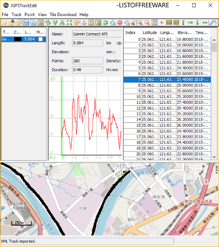
JGPSTrackEdit is a free portable TCX file viewer for Windows. It is a Java-based software, so it requires Java to be installed on your system to run.
You can simply import track data from TCX file in it. It displays containing track points with respective information including track point number, latitude, longitude, elevation, and timestamp. Besides that, it also displays some statistics related to the track with a graph. The track statistics shown in it include length, total points, density, duration, driving time, etc. Additionally, it shows the series of track points on the map. You can select the desired map service to visualize track data including OpenStreetMap, OpenCycleMap, MapQuest (Satellite), 4UMap, HikeBikeMap, etc. You can zoom in (or out) the map to look at the track points closely. Plus, it lets you zoom selected track or a selected track point.
Additional Features:
- You can customize the view of the TCX file using options like show coordinate, show day tour markers, point information, distance measurement, show track length, etc.
- This software lets you edit the imported TCX file by adding new track points, deleting selected track points, reversing the order of track points, etc. You can even modify track points’ information like latitude, longitude, elevation, etc.
- Some handy options to manage or modify tracks are available in it, such as Split, Merge, Reverse, Compress, Update elevation, Correct points, Remove invalid points, etc.
- It supports file formats like GPX, KML, ASC, etc., to import and export.
- You can download tile images for offline use.
Conclusion:
It is one of the featured TCX viewer software on this list. As it is portable, you don’t need to install it and can directly run its application file to use it.
RouteConverter
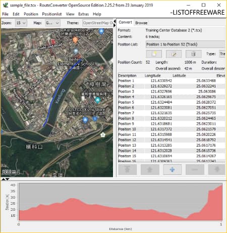
RouteConverter is another free portable TCX viewer software for Windows. It lets you view track data contained in a TCX file including tracks, track summary, track points, and track point information. On importing a TCX file, you can view number of tracks, position list, length, time duration, track point information, etc. It shows longitude, latitude, and elevation values of each track point. Not just that, it shows the tracks on the map using the selected map service. It supports a lot of map services like OpenStreet, Thunderforest, HikeBikeMap, OpenTopoMap, ArcGIS Online, Google Hybrid, Wanderreit, etc. Additionally, you can apply a map theme from available ones like Openandromaps Themes, gamesnight.co.uk Themes, Freizeitkarte Themes, etc.
Additional Features:
- You can view graph like Speed vs Time, Speed vs Distance, etc.
- Other than viewing a TCX file, you can modify it as well. You can edit track point info, add new track point, remove existing track points, modify track order, etc.
- It provides a Find Place option to directly insert a track point.
- You get some more tools to manage track data including split, merge, import tracks from another file, reverse track completely, sort by description or date & time, etc.
- It supports various import and export file formats such as GPX, KML, TRK, CSV, RTE, LOG, ASC, XLS, etc.
Final Thoughts:
It is a nice free TCX file viewer which is portable; hence, you can use it on the go without installation.
Garmin BaseCamp
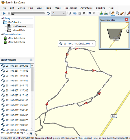
Garmin BaseCamp is a featured GPS data management software for Windows and Mac. Using it, you can view TCX files containing multiple tracks and track points. You can import a TCX file and view the track points on the map. The list of track points can be accessed from the left panel on its interface. On clicking a track point, it displays various information related to the track points including name, coordinates, elevation, depth, symbol, proximity, temperature, contact information, etc. Also, it shows the related statistics too such as number of points, distance, area, time, speed, etc. You can also view Elevation vs Distance and/or Speed graph.
More Features:
- It lets you apply data filters, sort track points, toggle between 2D and 3D views, align north up, view selected point on map, etc.
- You get a lot of tools to draw new waypoints, tracks, and routes; such as move point, insert, erase, divide, pan, zoom, measure, etc.
- It contains options like Find Points of Interest, Find Addresses, Find Places on Yelp, Find Intersection, etc.
- It lets you geotag photos using selected track.
- Furthermore, it provides useful tools including a trip planner, adventure creator, download BirdsEye imagery, install maps, etc.
- This software works well with multiple GPS information files like GPX, KML, KMZ, LOC, etc.
Conclusion:
Garmin BaseCamp is a great software to view and edit various files containing GPS information. You get a nice set of features in it with a clean and intuitive GUI.
GPS Utility
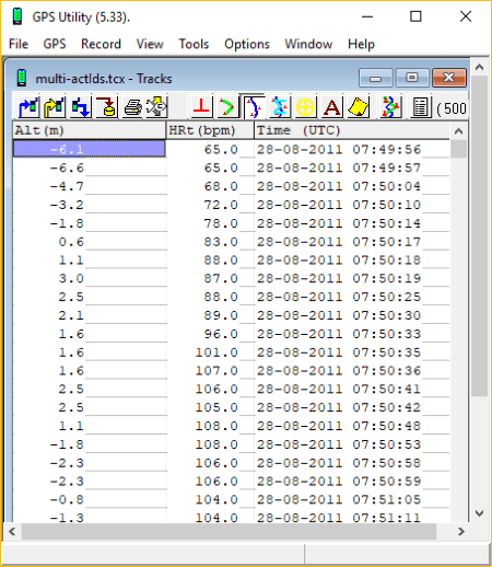
GPS Utility is a free software which lets you view and edit various GPS information file. Using it, you can view TCX file and other files containing routes, tracks, and waypoints such as GPX, KML, WPT, RTE, TRL, ASC, GTR, TXT, CSV, etc. As you import a TCX file, it displays all containing track points with respective information on its main interface. You can view points’ information including GPS coordinates, altitude, time, duration, etc. It provides you the flexibility to customize unit (coordinate format, horizontal units, etc.) of these parameters to view information accordingly.
Additional Features:
- You can customize view properties of a TCX file including datum, current view (waypoint, track points, track summary, route, etc.), map view, see waypoint description, etc.
- On clicking a waypoint, you can view as well as edit corresponding data such as latitude, longitude, timestamp, altitude/depth, etc.
- It allows you to remove particular track points from the current TCX file.
- You can merge two or more TCX or supported file into one single file.
- It provides some handy options such as Mark Hidden, Mark Normal, Mark Highlighted, Select Next Hidden, etc.
- In its Tools menu, it contains a lot of useful features which include Create Waypoint from Trackpoints, Break/Join Track, Smooth Altitude, Calibrate Altitude/Depth, Swap Altitude-Depth, Correlate JPG files, etc.
- You can print the GPS data or export it to another supported file format.
Limitation:
The freeware edition of this software displays at most 500 track points or waypoints. Plus, some features are also locked in it. To be able to fully utilize it, you need to purchase the pro version of this software.
Conclusion:
It is a standard TCX and other GPS data file viewer with a simple GUI. You can customize a lot of properties to view GPS data in it, such as Map Settings, Map Appearance, Data Set, Symbol Sets, etc.
3D Route Builder
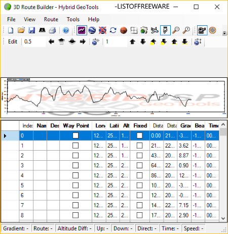
3D Route Builder is yet another free TCX viewer software for Windows. It is nice and easy to use software to view and edit TCX as well as other GPS data files including KML, KMZ, and GPX. You can view all track data contained in a TCX file on its interface, such as waypoints, name, description, longitude, latitude, altitude, distance, time, etc. It also displays an Altitude vs Distance graph on the main interface.
Features to look out for:
- It lets you import a track or route file using the respective URL.
- You can edit basic waypoint information in a TCX file including name, description, and altitude.
- If you want, you can remove some selected waypoints from a TCX file.
- You can import route from another supported file and add it to the current TCX file.
- It lets you export track data as CSV, XML, GPX, KML, or any other supported file.
Limitations:
- It is free for non-commercial use only.
- You can view at most 500 waypoints in the free version.
- Some of its tools didn’t work fine during my testing.
Conclusion:
It is a decent TCX file viewer using which you can view track or route data contained in a TCX file and other supported file.
TCX Converter
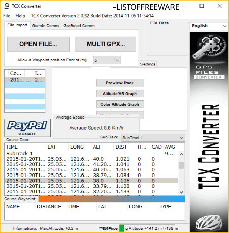
TCX Converter is the next free TCX viewer software on this list. As the name suggests, it basically converts TCX files and other supported file from one to another format. It shows sub tracks and track points as you import a TCX file. You can view information about a track point including latitude, longitude, altitude, distance, etc. Furthermore, it lets you view altitude graph, color altitude graph, and pendence histogram.
Additional Features:
- You can export an imported TCX file in other formats like GPX, TRK, KML, CSV, FIT, etc.
- It lets you import multiple GPX files together, merge them into one file, and export it in any supported file.
Conclusion:
It is a basic TCX file viewer whose interface is quite dated. And also, it contains a lot of features, but many of them didn’t work well during my testing.


About Us

We are the team behind some of the most popular tech blogs, like: I LoveFree Software and Windows 8 Freeware.
More About UsArchives
- May 2024
- April 2024
- March 2024
- February 2024
- January 2024
- December 2023
- November 2023
- October 2023
- September 2023
- August 2023
- July 2023
- June 2023
- May 2023
- April 2023
- March 2023
- February 2023
- January 2023
- December 2022
- November 2022
- October 2022
- September 2022
- August 2022
- July 2022
- June 2022
- May 2022
- April 2022
- March 2022
- February 2022
- January 2022
- December 2021
- November 2021
- October 2021
- September 2021
- August 2021
- July 2021
- June 2021
- May 2021
- April 2021
- March 2021
- February 2021
- January 2021
- December 2020
- November 2020
- October 2020
- September 2020
- August 2020
- July 2020
- June 2020
- May 2020
- April 2020
- March 2020
- February 2020
- January 2020
- December 2019
- November 2019
- October 2019
- September 2019
- August 2019
- July 2019
- June 2019
- May 2019
- April 2019
- March 2019
- February 2019
- January 2019
- December 2018
- November 2018
- October 2018
- September 2018
- August 2018
- July 2018
- June 2018
- May 2018
- April 2018
- March 2018
- February 2018
- January 2018
- December 2017
- November 2017
- October 2017
- September 2017
- August 2017
- July 2017
- June 2017
- May 2017
- April 2017
- March 2017
- February 2017
- January 2017
- December 2016
- November 2016
- October 2016
- September 2016
- August 2016
- July 2016
- June 2016
- May 2016
- April 2016
- March 2016
- February 2016
- January 2016
- December 2015
- November 2015
- October 2015
- September 2015
- August 2015
- July 2015
- June 2015
- May 2015
- April 2015
- March 2015
- February 2015
- January 2015
- December 2014
- November 2014
- October 2014
- September 2014
- August 2014
- July 2014
- June 2014
- May 2014
- April 2014
- March 2014
