4 Best Free FIT File Editor Software for Windows
Here is a list of best free FIT file editor software for Windows. Using these free software, you can view and edit FIT files. FIT i.e. Flexible and Interoperable Data Transfer is a file format developed by Garmin used to store GPS points, tracks, and routes. You can edit many other GPS track files with these software including GPX, KML, TCX, TRK, etc.
To edit FIT files, you can change waypoints or track points’ information such as latitude, longitude, altitude, name, description, symbol, etc. You can also add new track points, delete existing ones, reorder them, reverse their order, etc. These software let you create new routes and tracks too. It also lets you import another supported GPS data file to merge into the current FIT file. Additionally, you can choose the desired map service to view and edit FIT files. After editing FIT file, you can convert and save the modified version in some other file format like GPX, KML, TCX, WPT, LOC, CSV, etc.
My Favorite FIT File Editor for Windows:
Garmin BaseCamp is one of my favorite software because it is a featured software and it supports a lot of formats other than FIT, such as GPX, KML, TCX, LOC, etc. If you want a simple yet effective FIT file editor, try GPS Utility.
Also, you may checkout lists of best free TCX File Editors, GPX File Editors, and FIT File Viewers for Windows.
Garmin BaseCamp
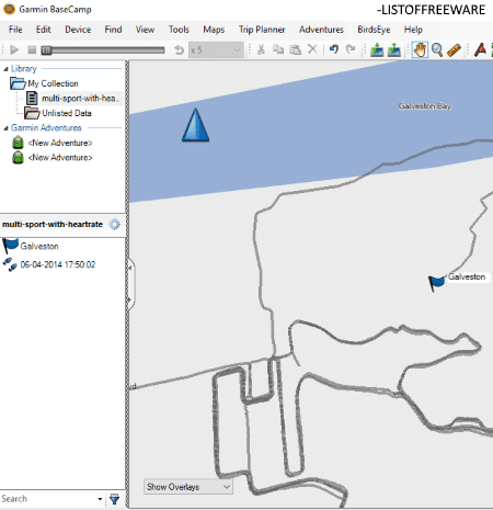
Garmin BaseCamp is a free GIS software for Windows. In it, you can also view and edit FIT files as well as GPX, KML, TCX, LOC, etc. files.
How to edit FIT files in Garmin BaseCamp:
Firstly, import one or more FIT files to its library. As you select a FIT file, you will be able to view its waypoints, tracks, and routes on the map and in the left panel. You can now use various provided tools in order to edit FIT files. These tools include select, pan, zoom, insert, divide, erase, measure, etc. You can also create new waypoints, routes, and tracks. Additionally, you can delete waypoints, invert waypoints, split track, move track point, create the route from selected track, etc.
To view a FIT file, it provides 2D and 3D maps, fullscreen mode, data filter (waypoints, tracks, routes, etc.), and more. You can view various statistics related to a FIT file like points, distance, speed, elevation, area, time, etc. It also displays graphs including Speed v/s Distance and Elevation v/s Distance. It provides a Trip Planner tool to create a new trip.
To export edited version of FIT file, it supports TCX, GPX, KML, CSV, TXT, etc. formats.
All in all, it is a nice free software to edit FIT files. You can find a lot of handy tools in it such as Find Places on Yelp, Find Points of Interest, Find Addresses, BirdsEye Imagery, Create Adventure, etc.
GPS Utility
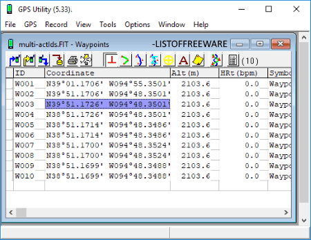
GPS Utility is another free FIT file editor on this list. You can view and edit a FIT file using this software. After opening a FIT file, you can view its waypoints, track points, routes, track summary, etc. in a spreadsheet-like tab. Also, it lets you enable map view to preview points and tracks. You can select a waypoint or track point and edit its information like latitude, longitude, altitude, heart rate, timestamp, etc. Additionally, it allows you to add new waypoints/ track points, remove selected points, reverse track points, etc. Other than that, you can find various useful tools to manipulate a FIT file such as Break/Join Track, Calibrate Altitude/Depth, Mark/Unmark Track Points, Create Waypoint from Trackpoints, Swap Altitude and Depth, Smooth Altitude, Correlate JPG files, etc.
You can’t save the edited FIT file in its native format but if you want, you can save the edited version in many other formats including TCX, GPX, KML, RTE, WPT, MAP, etc. Plus, you can import and edit these files in this software.
Note: The free version of GPS Utility is limited in terms of datasets as it supports at most 100 waypoints, 500 track points, 5 routes.
RouteConverter
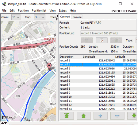
RouteConverter is the next free FIT file editor software for Windows. Apart from FIT files, it supports a wide number of GPS data files to edit, such as TCX, GPX, KML, WPT, LOC, TRK, RTE, POI, etc. You can simply import a FIT file and edit its GPS information including waypoints, routes, and tracks.
As you open a FIT file, it shows the containing waypoints’ information and statistics like length, duration, etc. You can also view waypoints, tracks, and routes on the map using services like OpenStreet, Thunderforest, HikeBikeMap, OpenTopoMap, etc. It lets you modify an existing waypoint’s latitude, longitude, and elevation. You can even add new waypoints, remove an existing one, change the order of waypoints, and/or reverse waypoints. It also provides an option to import track points, routes, etc., from an external supported file. You can find a handy Find Place feature in it, which lets you look for a location manually and add it to the track or route. Additionally, you can convert routes to tracks or vice versa.
The edited FIT file can be saved in the formats of TCX, GPX, KML, RTE, TRK, LOC, CSV, XLS, etc.
Notepad++
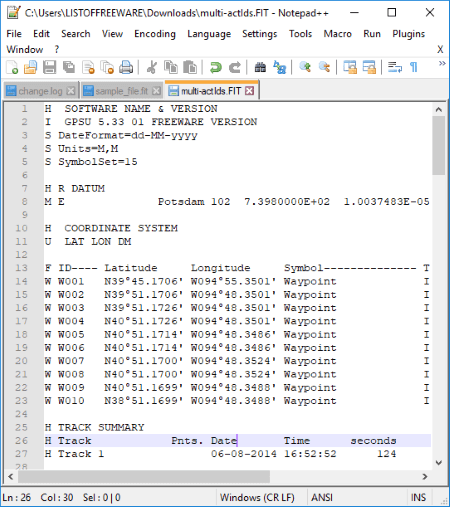
Notepad++ is a popular text and code editor for Windows. This can be your alternative to a FIT file editor. You can manually edit a FIT file in this software. In a similar manner, it can also be used to edit GPX, KML, TCX, etc. files too.
It lets you open a FIT file and view the containing waypoint, tracks, etc., as you can see in above screenshot. The points are shown with respective information like latitude, longitude, altitude, date, time, speed, etc. You can edit this data, manually add new points, remove an existing point, move a point up/down, change the order of points, etc. After making modifications, you can save them in the original FIT file itself.


About Us

We are the team behind some of the most popular tech blogs, like: I LoveFree Software and Windows 8 Freeware.
More About UsArchives
- May 2024
- April 2024
- March 2024
- February 2024
- January 2024
- December 2023
- November 2023
- October 2023
- September 2023
- August 2023
- July 2023
- June 2023
- May 2023
- April 2023
- March 2023
- February 2023
- January 2023
- December 2022
- November 2022
- October 2022
- September 2022
- August 2022
- July 2022
- June 2022
- May 2022
- April 2022
- March 2022
- February 2022
- January 2022
- December 2021
- November 2021
- October 2021
- September 2021
- August 2021
- July 2021
- June 2021
- May 2021
- April 2021
- March 2021
- February 2021
- January 2021
- December 2020
- November 2020
- October 2020
- September 2020
- August 2020
- July 2020
- June 2020
- May 2020
- April 2020
- March 2020
- February 2020
- January 2020
- December 2019
- November 2019
- October 2019
- September 2019
- August 2019
- July 2019
- June 2019
- May 2019
- April 2019
- March 2019
- February 2019
- January 2019
- December 2018
- November 2018
- October 2018
- September 2018
- August 2018
- July 2018
- June 2018
- May 2018
- April 2018
- March 2018
- February 2018
- January 2018
- December 2017
- November 2017
- October 2017
- September 2017
- August 2017
- July 2017
- June 2017
- May 2017
- April 2017
- March 2017
- February 2017
- January 2017
- December 2016
- November 2016
- October 2016
- September 2016
- August 2016
- July 2016
- June 2016
- May 2016
- April 2016
- March 2016
- February 2016
- January 2016
- December 2015
- November 2015
- October 2015
- September 2015
- August 2015
- July 2015
- June 2015
- May 2015
- April 2015
- March 2015
- February 2015
- January 2015
- December 2014
- November 2014
- October 2014
- September 2014
- August 2014
- July 2014
- June 2014
- May 2014
- April 2014
- March 2014
