5 Best Free Geotagging App For Android
Here is a list of best free geotagging app for Android. Geotagging is the process of adding geotags and geolocation data to images. A geotag contains various information such as Longitude, Latitude, Location name, Address, Altitude, etc. Adding geotags to photos allow users to find out where a specific image was taken. If you also want to add geotags to images, then check out these apps. All of these apps come with an inbuilt camera app to capture images and immediately add all the geotag data to captured images. Through some of these apps, users can even add geotags information to the metadata of existing images. To fetch the geotagging information, these apps use GPS and Cellular Networks. Besides this, these apps also offer tools to manually edit the geotag information.
Through most of these apps, users can also add a geotag template over images like a watermark. Before doing that, users can specify which information a template should contain like Longitude, Altitude, Location Name, Weather, etc. After specifying the geotag metadata and template information, users can capture images and add geotag information to them. To help users perform the geotagging operation, I have included the necessary steps in the description of each app. Go through the list to know more about these apps.
My Favorite Geotagging App For Android:
GeoTag is my favorite app as it can add geotag metadata to images captured through this app as well as to other existing images. Plus, it also lets users manually edit the geotag information before adding them to images.
You can also check out lists of best free Android EXIF Editor, Dish Pointer, and EXIF Remover app for Android.
GeoTag by Andrei Burdenkov
GeoTag is a free geotagging app for Android. Using this app, users can easily add geotags or location metadata to images. It can add geotag metadata to both existing images and images captured by this app. It also gives users a geotag editing tool through which users can manually add, edit, and delete geotag information like longitude, latitude, azimuth, location name, etc. Apart from adding geotag data as the metadata of images, this app can even add geotag data over images as a watermark or template. Now, check out the below steps to add geotag to photos using this app.
How to add geotag to photos on Android using GeoTag:
- Launch this app and click a photo using its inbuilt camera to immediately add geotag to it. Besides this, users can select existing images from the gallery to add geotag information to them.
- To add metadata to existing images, users need to use the Edit Info tool and manually add all the geotag data.
- After adding geotag data to images, users can view them over the virtual map.
- In the end, users can export the geotag data in KML, CSV, or XLS file format.
Additional Feature:
- Report: This app also lets users create a geotag report that carries the image along with its geotag data. Users can save the report in PDF, Excel, and CSV formats.
Final Thoughts:
It is one of the best free geotagging app for Android that can automatically add geotag metadata to all images captured by this app. Plus, it also lets users manually add and edit the geotag information of images.
GPS Map Camera
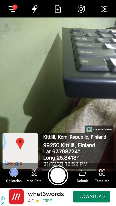
GPS Map Camera is another free geotagging app for Android. Through this app, users can capture images and add geotag metadata to them. This app can fetch your current geolocation using connected network and GPS features. As soon as users capture an image through this app, it will add a geotag template over the captured image. Although, it still adds the geotag data on the metadata of images. It also lets users manually edit the geotag information such as latitude, longitude, location name, address, etc. In addition to that, it also lets users manually add more fields over the geotag templates such as Wind, Weather, Compass, Altitude, Pressure, etc. After editing the template information, users can take more photos to add new geotag information over them. Now, follow the below steps.
How to add geotag to photos on Android using GPS Map Camera:
- Start this app and go to Map Data tag to let this app automatically fetch GPS data using your current location or use the manual method to manually add all the geotag data.
- After that, go to Template to add geotag fields that you want to show over the captured images like latitude, longitude, date, time, altitude, etc.
- Lastly, capture the image using this app to add geotag template and metadata to it.
Limitation:
- The free version of this app shows ads on its interface. Plus, it also ads its watermark on captured images. To remove ads and watermark, users need to purchase its premium version.
Final Thoughts:
It is another good geotagging app for Android that not only adds geotag to the metadata of images but also adds a geotag template over captured images.
GPS Map Camera by JK.Fantasy
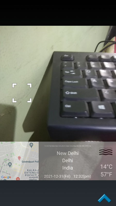
GPS Map Camera is another free geotagging app for Android. This app can add geotag information to all images captured by it. Unlike some other similar apps, it cannot add geotag info to existing images. By default, it fetches your current geotag information using GPS and cellular networks. Although, it also lets users manually specify the geotag information that they want to add over images. This app also adds a geotag template over images that contain a small street view map, name of the location where the image was captured, time, temperature, etc. By using the Draw style field, users can add remove various information from the template like map, LAT/LNG, address, weather, etc. After specifying all the parameters, just start capturing images to add geotag metadata and template to captured images. Now, check out the below steps.
How to add geotag to photos on Android using GPS Map Camera:
- Open the interface of this app and click on the Add button to automatically fetch geotag information or add geotag information manually.
- After that, go to the Draw Style section to specify the fields you want over the geotag template.
- Next, click on the Shutter button to capture the image and geotag information to it.
Additional Feature:
- File Name Format: It is another handy tool that allows this app to add geotag data with the names of captured images like address, latitude, longitude, etc.
Limitation:
- The free version of this app shows ads on its interface. To remove ads, users need to purchase their yearly subscription.
Final Thoughts:
It is another capable geotagging app for Android that offers all the essential tools to add geotag templates and metadata to images.
GPS Camera by U-Translate.Inc
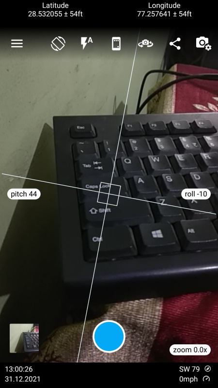
GPS Camera is yet another free geotagging app for Android. Using this app, users can easily add geotag templates as well as geotag metadata to images captured through this app. This app uses the GPS and cellular network to automatically find your current geolocation data. Although, it also gives users the freedom to manually specify the geotag information like latitude, longitude, area name, address, etc. It also offers a Template section that allows users to specify which information they want to add over geotag template like map, address, latitude, date, weather, etc. Plus, users can also specify the exact position of the geotag template over capture images. Now, follow the below step to add geotagging information to images.
How to add geotag to photos on Android using GPS Camera:
- Start this app and go to the Map data field to specify the exact geotag data you want to add in the metadata of images like GPS Coordinates, Location, Address, Map, etc.
- After that, move to the template field and specify all the geotag fields you want over the geotag template.
- Next, specify the position of the template over images.
- Lastly, start capturing images to add specified geotag metadata and templates over them.
Additional Feature:
- Video Geotag: This app can also add geotag metadata and templates to videos captured through this app.
Limitation:
- The free version of this app shows ads on its interface. By purchasing its premium version, users can remove ads.
Final Thoughts:
It is another good geotagging app for Android that can add geotagging information and templates to both photos and videos.
GPS Status by All Excellent Apps
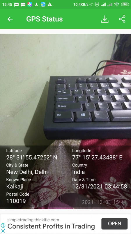
GPS Status is another free geotagging app for Android. Through this app, users can add geotag metadata to both existing images and images captured through this app. By default, it fetches geotag info (Latitude, Longitude, Address, Altitude, and more.) using GPS and cellular networks that users cannot manually change. Although, user can specify which geotag parameter this app show add to images by going to Picture and Share Location preferences. Now, follow the below steps.
How to add geotag to photo on Android using GPS Status:
- Launch this app and go to Setting and specify the geotag info you want to add to images like Latitude, Address, Location Name, etc.
- After that, go to the home section and check out all the geotag information fetched by this app along with the street view map.
- Next, click on the Photos icon and choose Camera to capture images or choose Gallery to add geotag information to existing images.
Additional Features:
- GPS Status: In this section, users can save GPS location and geotag information of various places like Home, Office, Friends Home, etc.
- Copy to Clipboard: Use this tool to copy all the fetched geotag information to the clipboard that you can save as text.
Final Thoughts:
It is another good geotagging app for Android that anyone can use to add geotag information to the metadata of previously existing and captured images.


Naveen Kushwaha
Passionate about tech and science, always look for new tech solutions that can help me and others.
About Us

We are the team behind some of the most popular tech blogs, like: I LoveFree Software and Windows 8 Freeware.
More About UsArchives
- May 2024
- April 2024
- March 2024
- February 2024
- January 2024
- December 2023
- November 2023
- October 2023
- September 2023
- August 2023
- July 2023
- June 2023
- May 2023
- April 2023
- March 2023
- February 2023
- January 2023
- December 2022
- November 2022
- October 2022
- September 2022
- August 2022
- July 2022
- June 2022
- May 2022
- April 2022
- March 2022
- February 2022
- January 2022
- December 2021
- November 2021
- October 2021
- September 2021
- August 2021
- July 2021
- June 2021
- May 2021
- April 2021
- March 2021
- February 2021
- January 2021
- December 2020
- November 2020
- October 2020
- September 2020
- August 2020
- July 2020
- June 2020
- May 2020
- April 2020
- March 2020
- February 2020
- January 2020
- December 2019
- November 2019
- October 2019
- September 2019
- August 2019
- July 2019
- June 2019
- May 2019
- April 2019
- March 2019
- February 2019
- January 2019
- December 2018
- November 2018
- October 2018
- September 2018
- August 2018
- July 2018
- June 2018
- May 2018
- April 2018
- March 2018
- February 2018
- January 2018
- December 2017
- November 2017
- October 2017
- September 2017
- August 2017
- July 2017
- June 2017
- May 2017
- April 2017
- March 2017
- February 2017
- January 2017
- December 2016
- November 2016
- October 2016
- September 2016
- August 2016
- July 2016
- June 2016
- May 2016
- April 2016
- March 2016
- February 2016
- January 2016
- December 2015
- November 2015
- October 2015
- September 2015
- August 2015
- July 2015
- June 2015
- May 2015
- April 2015
- March 2015
- February 2015
- January 2015
- December 2014
- November 2014
- October 2014
- September 2014
- August 2014
- July 2014
- June 2014
- May 2014
- April 2014
- March 2014
