8 Best Free Picture Location Finder Software For Windows
Here is a list of Best Free Picture Location Finder Software For Windows. Using these software, you can easily find picture location i.e. location where a specific photo was taken. To do so, these image location finders locate photos on the map and also display location coordinates (longitude, latitude). In many of these, you can even geotag photos and locate photos on the map or manually edit location information. The location view can be changed to Map, Satellite, Terrain, or Hybrid view mode. Easy navigation options are also provided in these image location finders.
Each of these picture location finders has distinct features. For example, some of these can even fetch exact location of photos with address, you can locate multiple images on map simultaneously, finding altitudes of photos, etc. In most of these, you can view image EXIF info that includes camera make, model, camera settings, shutter speed, white balance, focal length, etc. information. The supported formats in these image location finders include JPG, PNG, TIFF, BMP, GIF, camera-specific image files, etc.
My Favorite Picture Location Finder For Windows:
Photo GPS Extract is my favorite photo location finder. It is a simple yet effective software to find picture location. It also provides a desirable Batch GPS Extractor tool.
You may also like some best free EXIF Editor Software, GIS Software, and Map Making Software for Windows.
Photo GPS Extract
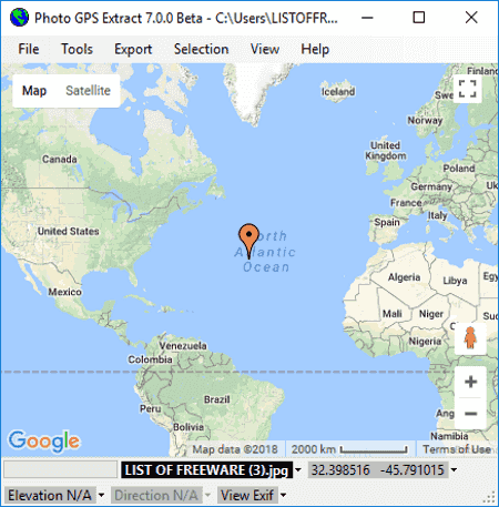
Photo GPS Extract is a nice free image location finder software for Windows. It can find picture location for JPEG images only. As you add an image to this software, it displays image location on the main screen. You can even load multiple images at a time and toggle between them to view respective image location. In addition to that, you can load a directory of images and view their locations on the map at once. The image location can be viewed in Satellite mode too. The best part about this image location finder is that it provides a Batch Extractor tool. It finds exact locations of multiple images simultaneously and lists the fetched information with respective addresses.
Features worth mentioning in this picture location finder:
- You can customize map view by configuring Map Type (RoadMap, Satellite, Hybrid, Terrain), Marker, Tracks, etc.
- It lets you print the map displaying locations of different images. Also, the results can be exported in formats like HTML, GPX file, KML file, etc.
- It also provides a desirable Street View Browsing feature to see a 360° panorama of the location of picture.
- It provides a tool which lets you generate embedded Google maps.
- Some other handy tools include selection tool, measuring tool, simulate camera, and find location on map.
Photo GPS Extract is one of the best picture location finder software for Windows.
GeoSetter
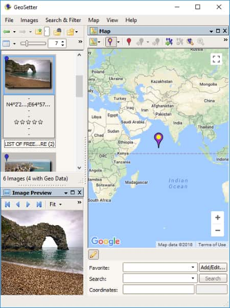
GeoSetter is a free picture location finder for Windows. It lets you add a folder of different images and find their locations on the global map with their coordinates. You can easily zoom in/out the map as required. The location map can be viewed in different modes including Google Satelite Map, Google Street Map, Google Hybrid Map, Google Terrain Map, OpenStreetMap, etc. You can also enable Overview Map mode. You can personalize map view using options like assign marker to selected images, show position markers, show image position, add direction to selected images, show image info on map, etc.
You can toggle between multiple images from left panel. There, you can also view EXIF data of images. On clicking an image, you can edit image data including location, date, source/description, category, etc. Some other features of this image finder location include Export to Google Earth, Copy Data to Clipboard, Search & Filters, etc. You can also setup general configurations such as data preference, ExifTool, Cameras, etc.
It supports general as well as camera specific image files including JPEG, TIFF, DNG, Canon, Nikon, Sony, Panasonic, etc.
Overall, it is a nice and multilingual picture location finder. It supports different languages including Italian, Spanish, French, etc.
GeoPhoto
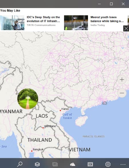
GeoPhoto is a free picture location finder app for Windows 10. This Windows app lets you find the location where your picture or any specific photo was clicked.
To start with, you need to add a folder of pictures to check their locations. This can be done using settings button. The pictures from that folder with location information will be viewed on the global map on its main interface. You can easily zoom into the global map to view the exact location. Other than Map, it also provides Satellite, Terrain, and Hybrid view modes to see the picture locations. You can also search for a location on the map.
It also provides a useful tool to view pictures without geotagging and add or edit geotag information for an image from added folder. The image can be directly shared via Flickr, OneDrive, Instagram, etc.
All in all, it is a good image location finder app with hassle-free interface.
Geotag
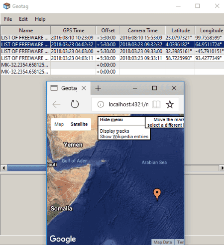
Geotag is another free image location finder software for Windows. It lets you add an image or a folder containing multiple images and view respective image locations.
When you add an image or image folder, you can view EXIF information of all added images which include longitude, latitude, altitude, etc. By right-clicking an image, you can view its location on the map. You can view image location in a browser or directly on Google Earth. It also provides an option to view location with directions. You can choose whether you want to view a single image on map or all added images together. There is also a Location names option which finds out exact location i.e. city, province, country, etc. and shows the information on the interface.
Apart from above features, it offers Find altitude, Save new locations, Copy Location, Copy time offset, Set time of image, etc. options. You can load tracks from file or GPS. General preferences like external browser, EXIF tool, coordinate format, distance unit, etc. can also be set up.
It supports JPEG, RAW, and TIFF image files.
Geotag is a portable picture finder software which requires no installation to run.
IrfanView
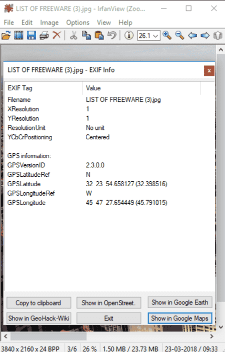
IrfanView is a famous graphics viewer and editor software for Windows. It can also be used as a photo location finder software (click on above image).
How to find picture location using IrfanView
Open an image in any of supported formats and go to Image menu > Information option. Here, you can view image metadata including EXIF and IPTC info. Using Exif info button, you can view GPS information related to the added image. Now, you can locate the picture on the map using online services namely, OpenStreet, Google Earth, and GeoHack – Wiki. That’s it. As simple as that.
IrfanView can be used for various other utilities which you may or may not know of, such as checking image DPI, watermarking images, batch file renaming, etc.
onAround Immageo
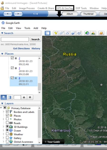
onAround Immageo is another alternative to an image location finder. It requires Google Earth to show image location on the map. Google Earth is a familiar geospatial application for different platforms including Mac, Linux, Android, iPad, etc. It comes in a software package too for Windows. You can download it from aforementioned link.
To view image location on map, add an image file to this software from PC, camera, or scanner. It also lets you add a whole folder of images. The supported image formats include JPG, TIF, BMP, PNG, GIF, etc. Now, go to GPS & GeoTag menu > Show Photos on Google Earth. You will be able to view image location on the global map. You can easily navigate through the map. General image metadata including longitude and latitude can be viewed and even edited from right panel. You can also add notes, tags, etc. to the pictures.
Note: Although this picture location finder provides a built-in map view to locate pictures on map, it wasn’t working fine while my testing.
GpsPrune
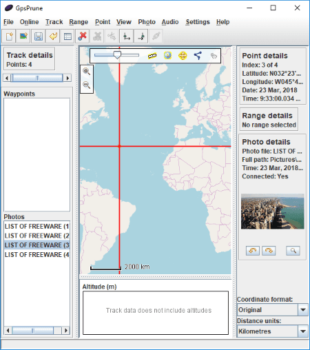
GpsPrune is a free, portable picture location finder for Windows. Just add JPG images to the software and it will display respective image location on the map. From the right panel, you can also view image information like latitude, longitude, etc. You can change the coordinate format and distance unit. Some other features of this software are Online (get altitude from SRTM, get Gpsies track, get weather forecast, open panorama map, etc.), Settings (set maps background, save map to disk, etc.), etc.
Photo Geo Editor
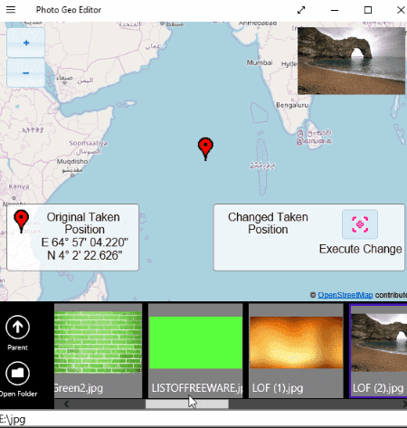
Photo Geo Editor is one more picture location finder in this list. It is an image location finder app for Windows 10. You can open a folder of images and view respective image locations one by one. It also displays location coordinates on the map. That’s it. It doesn’t offer any other option in its free version.
It is a simple and dedicated image location finder app for Windows.
About Us
We are the team behind some of the most popular tech blogs, like: I LoveFree Software and Windows 8 Freeware.
More About UsArchives
- May 2024
- April 2024
- March 2024
- February 2024
- January 2024
- December 2023
- November 2023
- October 2023
- September 2023
- August 2023
- July 2023
- June 2023
- May 2023
- April 2023
- March 2023
- February 2023
- January 2023
- December 2022
- November 2022
- October 2022
- September 2022
- August 2022
- July 2022
- June 2022
- May 2022
- April 2022
- March 2022
- February 2022
- January 2022
- December 2021
- November 2021
- October 2021
- September 2021
- August 2021
- July 2021
- June 2021
- May 2021
- April 2021
- March 2021
- February 2021
- January 2021
- December 2020
- November 2020
- October 2020
- September 2020
- August 2020
- July 2020
- June 2020
- May 2020
- April 2020
- March 2020
- February 2020
- January 2020
- December 2019
- November 2019
- October 2019
- September 2019
- August 2019
- July 2019
- June 2019
- May 2019
- April 2019
- March 2019
- February 2019
- January 2019
- December 2018
- November 2018
- October 2018
- September 2018
- August 2018
- July 2018
- June 2018
- May 2018
- April 2018
- March 2018
- February 2018
- January 2018
- December 2017
- November 2017
- October 2017
- September 2017
- August 2017
- July 2017
- June 2017
- May 2017
- April 2017
- March 2017
- February 2017
- January 2017
- December 2016
- November 2016
- October 2016
- September 2016
- August 2016
- July 2016
- June 2016
- May 2016
- April 2016
- March 2016
- February 2016
- January 2016
- December 2015
- November 2015
- October 2015
- September 2015
- August 2015
- July 2015
- June 2015
- May 2015
- April 2015
- March 2015
- February 2015
- January 2015
- December 2014
- November 2014
- October 2014
- September 2014
- August 2014
- July 2014
- June 2014
- May 2014
- April 2014
- March 2014
