5 Free Light Pollution Map Apps for Android
Here is a list of the best free light pollution map apps for Android. Light Pollution is excessive artificial light in the night sky. It is a rising concern among astronomers around the world. Excessive light impacts various astronomical observations and research. It can make it hard to locate and track distant planets, stars, and other objects in the sky. If you are concerned about light pollution or wanted to find a good place for watching the night sky then these apps can make it easy for you.
These apps have a light pollution map where you can see the level of light pollution around the world. The maps are interactive and you can search any location as well. Most apps use the Darksky database to help you locate the dark sites that are good for observing the night sky. These apps track weather conditions and astronomical information to tell how good a location is for stargazing. Some apps pack additional features such as ISS tracking, Northern Lights tracking, live cam/images from various observatories around the world, and more.
My Favorite Light Pollution Map App
LPM is my favorite light pollution map app on this list. This app shows an interactive map of light pollution around the world. You can explore the map with different terrain views and use features to find dark sites to observe the night sky. Apart from light pollution, this app packs many other features that a night sky enthusiast would appreciate. It can show live data from various sky and space observatories, track the moon, ISS, Northern Lights, and much more. You can also configure the app to get notifications and alerts for various astronomical events.
You can also check out our lists of the best free Online Light Pollution Map Websites, Map Maker Apps for Android, and Coronavirus Map Software For Windows.
Light Pollution Map - Dark Sky & Astronomy Tools
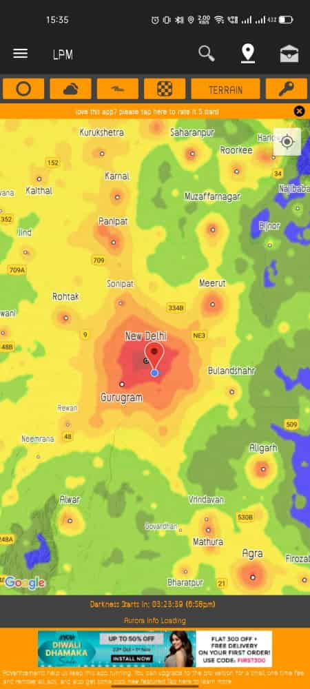
LPM is a free light pollution map app for Android. This app is designed to find dark sites where you can observe the night sky. The app shows light pollution levels around the world. You can interact with the map to see the level of light pollution and switch between different terrain. You can save and load locations on the map along with a “horizon safe radius tool” to see a safe radius with no light interference. Along with that, this app packs many other features for astronomers and casual night sky enthusiasts. It offers various types of information about the moon, sun, aurora, magnetic field, and more. Some of the features are paid but most of those you can access for free. The free feature also includes live tracking of ISS and live camera feed/images from various observatories around the world.
Main Features:
- Night Event Calendar: A calendar to track past, present, and future lunar eclipses, meteor showers, super moons, etc.
- Moon Direction Tool and Moon Info: Location the position of the moon in the sky and view moon phases, rise and set time, etc.
- ISS Tracker and Info: Track the orbit of the International Space Station and view the live ISS webcam.
- Live SOHO Feed: Access NASA’s Solar and Heliospheric Observatory to see images of the Sun.
- Live Aurora Cams: Watch the feed of live aurora borealis and magnetosphere graphs.
- Aurora and Magnetic Field Info: Get the aurora viewing probability, KP value, Magnetic Filed Bz, Speed, and Density.
- Astro Calculator: Built-in calculators for Orbits, Kinetic Energy, and Luminosity & Brightness. Astronomical Unit Calculator, Telescope Eyepiece Calculator, and Star Trails Calculator.
- Photo of the day: See a new astronomy photo every day.
- Aurora Visibility Map (Paid): Toggle an overlay of Aurora on top of a light pollution map to find the best location to observe the Northern Lights.
- Cloud Coverage & Temperature (Paid): Get real-time cloud coverage around the world along with a temperature heatmap.
- Notification Alerts: Get notifications for the next super moon, meteor shower, lunar eclipse, and aurora activity, and when the ISS passing nearby.
Night Earth Free
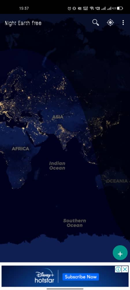
Night Earth Free is a free Android app with Light Pollution Map. This app shows light pollution around the world from various sources. You can easily toggle the map view and the source to view and compare the level of light pollution. You can compare the imagery from old and new databases. This app can also help you find locations with no or less light pollution. Apart from light pollution, this app can also day and night around the world. It can also show a real-time visualization of the Northern Lights. Thus, this is a nice app that you can use to check the level of light pollution.
Main Features:
- View Light Pollution level on the Earth from space.
- Compare the night images captured by NASA in 2000 and 2012.
- Real-time tracking of day/night around the world.
- Visualize Aurora Borealis and Aurora Australis in real-time.
- Toggle a cloud layer on top of the map.
- This app supports 3D View and VR view.
Meet Star Gazers
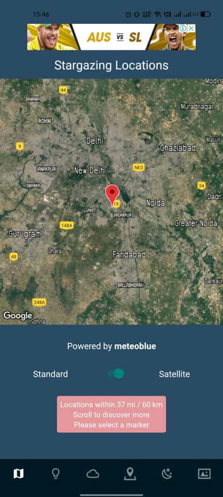
Meet Star Gazers is a free app designed to help people find places for stargazing. It opens with a map showing locations around the world that are good for observing the night sky. From there, you can switch to the light pollution map and see the level of light pollution around the world. You can interact with the map to explore different locations and check the level of light pollution. Along with that, this app can also show a cloud layer to track the cloud position for a particular location. You can view the astronomy weather for the location and track the lunar and solar ephemerides info as well.
Main Features:
- A map of light pollution to find dark sites for stargazing.
- A map of cloud coverage to view the real-time cloud position.
- View astronomy weather for the current location.
- View information of Lunar and Solar Ephemerides.
- See a new astronomy picture of the day.
Good To Stargaze for Astronomers
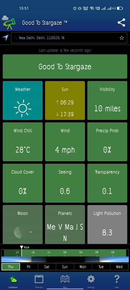
Good To Stargaze for Astronomers is a free Android app to check how good a location is for stargazing. You can enter a place in the app or let it access your location to know the stargazing conditions. It tells you if the location is good enough to see the night sky clearly. For that, it checks the weather, visibility, wind, precipitation probability, cloud coverage, moon, sun, planets, and light pollution. You can check for a week to find the best time for stargazing. With on tap, you can switch to the map view that shows you the light pollution map. You can interact with the map to explore and see the level of light pollution around the world.
Main Features:
- Check if a location is good for stargazing or not.
- View an interactive map of light pollution.
- Get a prediction on various aspects including weather, clouds, precipitation probability, wind, etc. over a week.
- Track the positions of the moon, sun, and planets.
- Get the light pollution score to see where a location stands on the light pollution index.
SoS: Light Pollution Map & Darksite Database
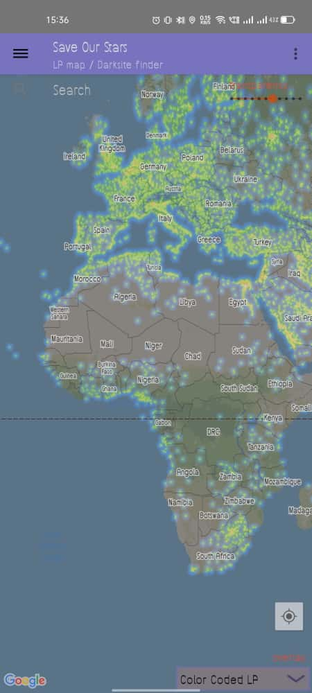
SoS is another free light pollution map app for Android. This app shows an overlay of light pollution on the map. You can change the transparency of the map to clearly see the level of light pollution around the world. There are two different layers of view the light pollution in this app. One layer is Visible (VIIRS 2106) that shows the visible lights from the space. The second layer is Color Coded Light Pollution that is an overlay. On top of that, you can access the Darksite database by signing in with a Google account. This lets you search dark sites around the world and save new sites in the app.
Main Features:
- A map to view the level of light pollution around the world.
- Access Darksite database to find places dark sites on the planet.
- Search and save dark sites by signing in with a Google account.


About Us

We are the team behind some of the most popular tech blogs, like: I LoveFree Software and Windows 8 Freeware.
More About UsArchives
- May 2024
- April 2024
- March 2024
- February 2024
- January 2024
- December 2023
- November 2023
- October 2023
- September 2023
- August 2023
- July 2023
- June 2023
- May 2023
- April 2023
- March 2023
- February 2023
- January 2023
- December 2022
- November 2022
- October 2022
- September 2022
- August 2022
- July 2022
- June 2022
- May 2022
- April 2022
- March 2022
- February 2022
- January 2022
- December 2021
- November 2021
- October 2021
- September 2021
- August 2021
- July 2021
- June 2021
- May 2021
- April 2021
- March 2021
- February 2021
- January 2021
- December 2020
- November 2020
- October 2020
- September 2020
- August 2020
- July 2020
- June 2020
- May 2020
- April 2020
- March 2020
- February 2020
- January 2020
- December 2019
- November 2019
- October 2019
- September 2019
- August 2019
- July 2019
- June 2019
- May 2019
- April 2019
- March 2019
- February 2019
- January 2019
- December 2018
- November 2018
- October 2018
- September 2018
- August 2018
- July 2018
- June 2018
- May 2018
- April 2018
- March 2018
- February 2018
- January 2018
- December 2017
- November 2017
- October 2017
- September 2017
- August 2017
- July 2017
- June 2017
- May 2017
- April 2017
- March 2017
- February 2017
- January 2017
- December 2016
- November 2016
- October 2016
- September 2016
- August 2016
- July 2016
- June 2016
- May 2016
- April 2016
- March 2016
- February 2016
- January 2016
- December 2015
- November 2015
- October 2015
- September 2015
- August 2015
- July 2015
- June 2015
- May 2015
- April 2015
- March 2015
- February 2015
- January 2015
- December 2014
- November 2014
- October 2014
- September 2014
- August 2014
- July 2014
- June 2014
- May 2014
- April 2014
- March 2014
